Showing posts with label Google Earth. Show all posts

Thursday, 14 August 2025

Albania-Macedonia, east of Dirac


 And... this is the last truly chaotic map I have to do of the Balkans. I'm so glad. There's still parts of Croatia and Slovenia to do to finish with the Balkans altogether, but this, this above... this horror show is finished. Yay.

I don't think the choice to do these larger sections is necessarily faster... I think it's more that when I get my teeth into a particular process, I'm less likely to put it down. One thing I find with a series of small jobs, when each in the string are finished, it's easier for me to throw off the next one for an hour, a day or even ten months. Whereas, something big like this... I'm not completely relaxed until it's done.

Anyway, I spent about 3.5 hours tidying this up today. and I think probably about 5 on it yesterday... which sounds like a lot. But when I think about the eight hour shifts I've worked in my life that have ended without anything real to show from it — and I know all of you know exactly what I mean — this really feels like time well spent.

So, this wraps up the Rumelia sheet for now, which the reader can compare with this from Aug 8, six days ago:

And it tidies up the Illyria sheet:

On Google Earth, we can see what's been finished overall in this corner of the globe:


Keeping in mind that everything in the upper right corner behind the red boxes has been mapped. It can be seen that I've worked a line north up to Sarajevo, then jumped way west through Croatia, which has steadily widened with each trip around the map that I've done. So I'm going to even that up now, pushing way into south Italy, then north, evening up that scraggling line. It's an opportunity to map a very different country (though Italy is going to be very densely infrastructured, all type-1 hexes) and a lot of coast. All of Italy is smaller than Romania and Serbia put together, but it's very long so finishing it will cover a lot of open sea, with Sicily and Sardinia being the last areas finished.

So, it's across the water with my next map, with the densest part of Apulia on the block.

Wednesday, 21 December 2022

K.30e - Kiyev Sheet

First of two posts today.  To begin, here's an image of the Kiyev sheet, to date.  Won't be finishing that upper right hand corner for awhile.


Labelling still needs work, at least from the standpoint of large pictures.  Got to darken up the geographical descriptions and the political labels also.  But, not pressing.  Play around with it going forward.

Here's an image of the Czernowitz and Kiyev sheets together:


Gets harder and harder to see the whole picture without having to give up a level of detail.  Mostly it's just lines and hexes, unless we know just what we're looking at.

On the subject of forward mapmaking ... yesterday I talked about the ragged edge of what's been mapped so far.  Here's an updated image from GoogleEarth for the sections that have been completed:


So, not nearly half of the Ukraine done.  It's a big country.  But the reader can see what I mean by the eastern edge.  My intention is to the continue with a southeast progression until coming even with the yellow rectangle on the map, though that means doing more that three sections in a line before moving south.  Then, with that evened up, I'll come southwest until I hit Bulgaria and Thrace in Turkey.  There's a small chance I'll map some of Bithynia, the bulge showing in Turkey south of the label for the Black Sea.  I'm actually looking forward to mountains.

Friday, 25 November 2022

Galicia, around Lesko

As I said with the last post, this is as far north as we go for awhile:


The west side includes a spur of the Carpathians that reaches north; Lesko is in the extreme southeast of modern Poland, of which Galicia is a modern province.  The province is heavily populated, more than 440 thousand.  Krakow, about 140 miles WNW of Lesko, has a population of 75,000.  Thus the main of the population and infrastructure is on the fat plain in west Galicia.  This part is comparatively less developed.  Keep an eye on that 10 infrastructure.


Presenting this as a wider shot because I've also completed the two hexes to the east, around Sambor.  The 10-infrastructure hex I mentioned presented no village at all, not even a type-5 hex, so it's a collection of scattered, isolated hamlets and thorps in the hill country shown.  The east side of the section was all small type-4 villages, with the exception of Lesko.  Shows a definite, rustic agrarian setting.  Nonetheless, it presents an important route through the Carpathians between Galicia and Upper Hungary.

The north edge of the completed part above is showing a thinning of the hills, so we're getting on the other side of the Carpathians now.  This is even more evident with the completed section around Sambor, below:


The hills, called the "Low Beskids," are definitely thinning now. As we go east, geographically the area becomes the Podolian upland. This area proved disastrous for the Russians and Austrians in World War I, as the region became frozen over and the armies on both sides were bogged down fighting over the rolling terrain. The German tanks rolled easily and quickly through this country when they advanced into Russia in 1941.

We've turned the corner on the map, so it's all east from here.  I'll provide a longshot without the background to provide a feeling for the method I'll follow:


The 60-degree slope is three 20-mile hexes high.  The reader should note that when we walked up through Hungary, the mapping was a swath 120 miles wide, with three sections end-to-end.  Now I'm only going to cut a 60-mile wide swath through Ukraine.

The main reason is that I have a great deal more east-west to create than north-south.  From where we are, it's only 32 degrees latitude to the top of the world's map, where as the same number of degrees longitude east only gets us to north of the Aral Sea.  It's a long, long haul around the world compared with mapping to the north or south, so the emphasis is to stretch out the map.

Out of interest, here's how much of the world I've mapped thus far:


The reader might remember that when starting the blog on November 9th, we were on a line with Budapest, so that should give a sense of what's been accomplished in just over two weeks.  Thankfully, it gets easier when crossing water or getting out of the more heavily populated areas, such as Hungary and gawd help us, getting into Italy, Germany and France.  That's a long way off.

Less villages means less roads, and when the hills drop away too, it's much easier to do three or four sections at a time, instead of just one.  Things should skip long fairly well once we're out of Lwow County.

The sharp-eyed reader might notice that the three sections at the top don't line up in a neat 60-degree angle, like the hexes do.  In fact, they're almost straight up and down.  This is because the hex layout distorts and stretches the flat Earth ... something I have to compensate for constantly, stretching out rivers and mountain ranges as needed.  This is one of the key reasons why making an "accurate" map is out of the question.  It would slow down the process stupidly anyhow.  And from the point of view of the game, the players and me, it's good.  I know when I'm fudging ... the players have zero idea, because they just don't know the world as well as I do.  Hell, for people who don't actually live in these spaces, or don't have a map to tell them, I imagine most would think I'm being dreadfully accurate.  I'm not ... heh heh.  I know it.  But it doesn't matter.

As explanation, the center "empty" part of the ring of red rectangles has been done, but as I go forward I'm deleting the old sections ... google earth gets tetchy when there are too many of them.  The blue rectangles are places where I had to define what was in those hexes for coastline purposes, but the actual mapping hasn't been done.

So, going forward, I'll build the bricks from the bottom up, trending slightly northwest with each line of three sections.  It'll go that way until we get to the next corner.  Soon enough, things start to get complicated for a completely different reason.

Friday, 18 November 2022

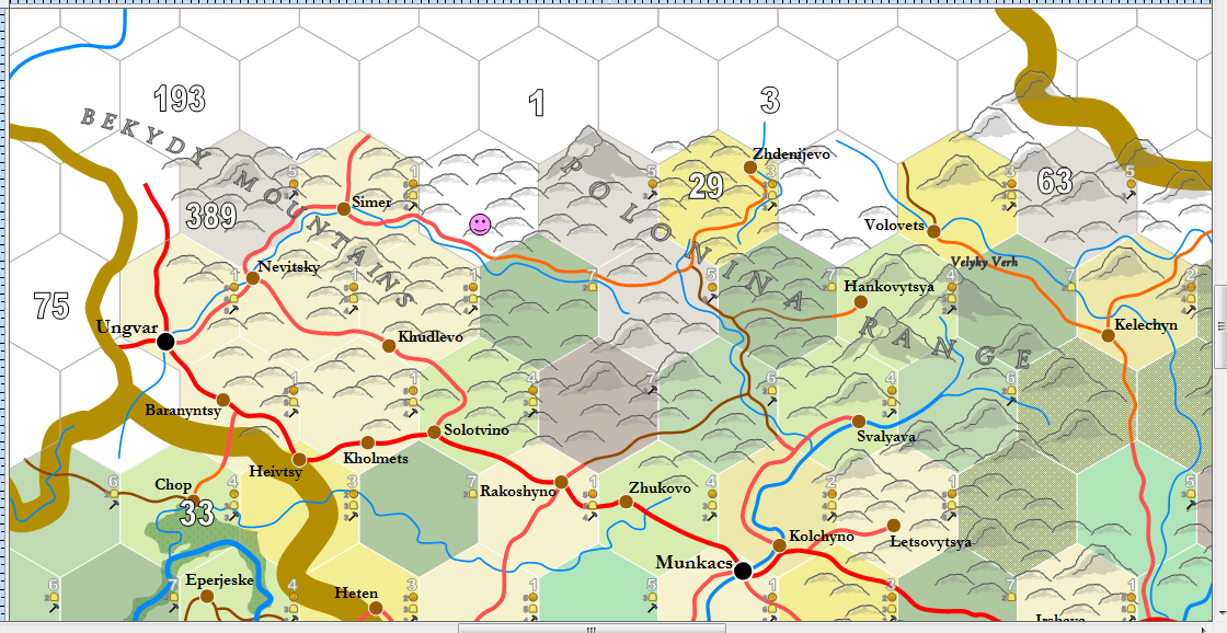
Ruthenia, around Ungvar

Coming up on the corner of the much earlier map, whereupon I'll be mapping eastward directly into the heart of the Ukraine.  I won't be heading south again until reaching a corner of the Dneiper river south of Kiyev.

Anyway, with the turn, I don't want the reader to get confused as to where we are, so here's a map from Google Earth showing what's been mapped so far and what I'm going to map next ... and in which order.


Google Earth lets me save all the sections I've mapped (up to a point, the memory starts to go and at that point I delete the oldest ones.  The red rectangles, or sections, are done.  We'll be moving into the blue ones.  In fact, the first blue one here is done, I did it today and it's posted below.  I'll be following the arrows until I get to the top of the pyramid.  Then I'll start going east, working from south to north with each three blocks.

As you can see, we're going to get into a lot of mountains ... and these will last a while, until we get out onto the Ukrainian plain, whereupon we won't see another significant mountain at least until we get to the Crimea.  Assuming I don't pass the mountains of Yalta as we go by.  But that's all for another day, probably about two to three months from now, going by this pace.  We might actually get back to this corner six months from now ... heh heh.

I failed to screenshot the next section before doing it, but there's a decent indication of it from the previous post.  Here it is completed, without background:


The above was a bit of a bitch.  The first rule of mountains, they are not empty.  ALL fantasy maps insist that mountains should be depicted as seas of peaks, without exception, despite how many Americans live in and around the Rocky Mountains and other ranges.  These places are not empty.  Cultures squeezed into narrow valleys between mountains go back 5,000 years ... and many of these were highly developed by the 1st millennium BCE.  There's plenty of room for a culture to farm and live in a valley just a mile wide ... so pack those people in.  Remember that the soil on a valley floor is often richer than that of an open plain.

Doing sections in the mountains is slow business.  The above took me 90 minutes.