Showing posts with label General Map. Show all posts

Wednesday, 13 November 2024

Kiyev-Zytomierz, west of Kiyev


Turns out, I am going to catch the city of Kiyev on this pass around before turning southeast.  This is a very tricky part of the map.  Passing the 30th parallel east, the direction of the map turns 30-degrees in the upper right corner shown; then another 30-degrees with the next three hexes.  Plus, this small corner, being at the top of the map, ends up being copied onto three different map sheets.  I'm working on sheet two right now so I can fill out the blank hexes above, then I'll be on sheet 3 to fill out the blank hexes there... and then I'll be on my way again, probably at a faster pace, because after Kiyev the population drops considerably and stays that way right to the Sea of Azov.  Then I cut through eastern Crimea, maybe or maybe not touch upon Kubanistan (the mainland opposite Crimea) then right across the Black sea to Anatolia.  That's when things begin to get interesting again, with mountains.

Friday, 20 January 2023

Bithynia, around Cide

Returning to Bithynia, there's only this small corner left, before leaving modern Turkey behind:


Everything else is south and east.  When I come back around this way, I'll be doing a great deal of Turkey ... but then Turkey is a very large country, bigger than France, so that I'll be adding to it for years to come.

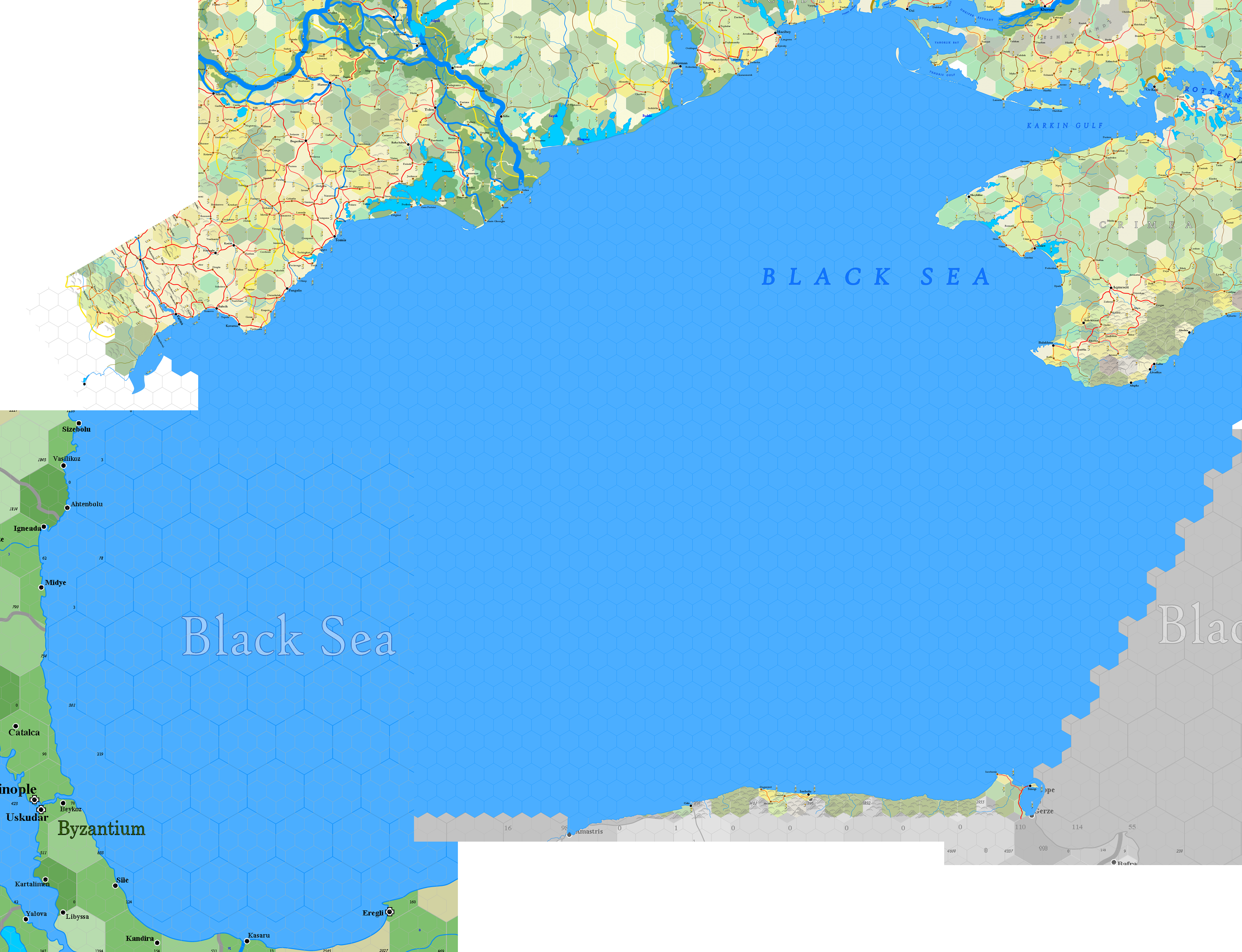
Before starting on Bulgaria, I thought I'd provide a general map of the coast around the Black Sea, to demonstrate how really huge it is with this scale:


Not all of this coast is mapped, obviously.  The big swing around Constantinople on the lower left swings too far south, so it won't be done on this pass.  This is also a part of the map where the direction of hexes turns 60 degrees, which is really obvious for anyone familiar with a world map.  With tomorrow's post, if someone doesn't intervene with a request, I'll fill in the coast on the middle left, which is Bulgaria, and start moving inland from there.

The reader can see that, although I'm only doing a small part each day, it's just taken two months to map an enormous part of Europe, from Hungary through the southern tip of Poland, across the Ukraine and down into the rim of Turkey.  In another two months we'll have reached the Adriatic Sea and, I hope, be on the verge of returning to Hungary.

Wednesday, 21 December 2022

K.30e - Kiyev Sheet

First of two posts today.  To begin, here's an image of the Kiyev sheet, to date.  Won't be finishing that upper right hand corner for awhile.


Labelling still needs work, at least from the standpoint of large pictures.  Got to darken up the geographical descriptions and the political labels also.  But, not pressing.  Play around with it going forward.

Here's an image of the Czernowitz and Kiyev sheets together:


Gets harder and harder to see the whole picture without having to give up a level of detail.  Mostly it's just lines and hexes, unless we know just what we're looking at.

On the subject of forward mapmaking ... yesterday I talked about the ragged edge of what's been mapped so far.  Here's an updated image from GoogleEarth for the sections that have been completed:


So, not nearly half of the Ukraine done.  It's a big country.  But the reader can see what I mean by the eastern edge.  My intention is to the continue with a southeast progression until coming even with the yellow rectangle on the map, though that means doing more that three sections in a line before moving south.  Then, with that evened up, I'll come southwest until I hit Bulgaria and Thrace in Turkey.  There's a small chance I'll map some of Bithynia, the bulge showing in Turkey south of the label for the Black Sea.  I'm actually looking forward to mountains.

Tuesday, 29 November 2022

Towards the Corner

This is my second post today; don't read the first.

The next section that needs to be done for the map is shown below.  It extends over the next sheet, K.26e - Czernowitz:


The reader can see the background has shifted, so that all the labels are turned 60-degrees clockwise.  The time has come to explain why.  Before reading this, you may want to familiarise yourself with this very old post.

Have a look at these two 20-mile map sheets:


The map on the left, "Carpathians," has served as the background for the mapping of Hungary, Slovakia and Ukraine that we've done so far, while the map on the right is what'll be used going forward.  The Danube Mouth has been turned 60 degrees clockwise, as compensation for the Earth's curvature.  While strange, and often annoying (as you'll see), this turn enables me to effect a huge, unbroken flat map of the game world without having to stretch the polar center flat, as in a Mercator projection:


This represents most parts of the world that I've mapped in 20-mile hexes.  I had a large part of China done, before (I believe) accidentally deleting the files; some of Mongolia has been done, and a big part of Africa south of the line shown.  The reader can clearly see how the curve of the Mediterranean twists into the levelling of the Black Sea (assuming you know where these are without needing labels), or how India twists towards the right as it approaches the 90th meridian east, where the map turns again into Burma.

This would bother some people.  You may note on the comments connected to the link above, to the old post, that a number of people have firmly suggested putting the map on an actual globe.  Of course, there are two big problems with that.  First, it's very difficult to fit the globe into a scanner, so it can be put online ... and two, none of the pundits suggesting the globe idea have done anything.  Nix, nada, nothing.  This may help explain my contempt for pundits in general.  Full of ideas, shit for making something.

The map turn is a bitch, no question about it.  Usually, a rectangular sheet map, like "Carpathians" above, always overlaps adjacent sheets by just two hexes, such as I demonstrated here (see bottom of post).  The "corner map" overlaps considerably more, to ensure I have complete coverage, as shown:


When I make a corner map, this is the template I use.  The orange line represents the parallel, say the 30th E, that dictates the turn taken.  The blue line follows a row of hexes, showing that as we move from west to east, we simply turn the roads in a new direction.  In a few weeks, you'll see this done and be amazed at how perfectly simple it is ... and how the result is undetectable at a close-up scale, even at 20-miles per hex.  The "overlap" shows how much of the Carpathians map folds over the Danube Mouth map ... thus we can see the turn of the Carpathian mountains, represented by brown hexes, on both maps, even though the Danube has them turned 60 degrees.  Finally, the bottom left of the map ends up extending deep into the ring of maps below.  Carpathians and Danube mouth are the "D-Ring."  The "E-Ring" appears on the Carpathian maps only as the bottom two hexes ... but the corner hex sucks up a great deal more of the E-Ring.  That's why we can see part of Thrace showing up on the Danube Mouth map.

This repetition of maps, so that both sheets are duplicates of the other, is an enormous headache.  They have to be nearly perfect as well, or else I could not put them together to create a single, great map, such as the big map of the world shown above.  Unfortunately, Publisher as a program ffing won't turn a picture 60 degrees without distorting it a tiny, tiny, tiny bit.  Just enough to grind my teeth.

So, as we move towards the 30th parallel (we're at the 26th), the distortions between the map being made and Google Earth increase, ever so slightly, and never in a way that can't be tolerated.  Then the overlap has to be compensated for.  And then, as we move away from the 30th, the map becomes less distorted and from thence forward, there's only a hassle when the 30th is actually approached and crossed.  I've already done enough work that the main center of the whole 6-mile map I've done is past that overlap.  Wasn't much fun, I can tell you.

Friday, 25 November 2022

Galicia, around Lesko

As I said with the last post, this is as far north as we go for awhile:


The west side includes a spur of the Carpathians that reaches north; Lesko is in the extreme southeast of modern Poland, of which Galicia is a modern province.  The province is heavily populated, more than 440 thousand.  Krakow, about 140 miles WNW of Lesko, has a population of 75,000.  Thus the main of the population and infrastructure is on the fat plain in west Galicia.  This part is comparatively less developed.  Keep an eye on that 10 infrastructure.


Presenting this as a wider shot because I've also completed the two hexes to the east, around Sambor.  The 10-infrastructure hex I mentioned presented no village at all, not even a type-5 hex, so it's a collection of scattered, isolated hamlets and thorps in the hill country shown.  The east side of the section was all small type-4 villages, with the exception of Lesko.  Shows a definite, rustic agrarian setting.  Nonetheless, it presents an important route through the Carpathians between Galicia and Upper Hungary.

The north edge of the completed part above is showing a thinning of the hills, so we're getting on the other side of the Carpathians now.  This is even more evident with the completed section around Sambor, below:


The hills, called the "Low Beskids," are definitely thinning now. As we go east, geographically the area becomes the Podolian upland. This area proved disastrous for the Russians and Austrians in World War I, as the region became frozen over and the armies on both sides were bogged down fighting over the rolling terrain. The German tanks rolled easily and quickly through this country when they advanced into Russia in 1941.

We've turned the corner on the map, so it's all east from here.  I'll provide a longshot without the background to provide a feeling for the method I'll follow:


The 60-degree slope is three 20-mile hexes high.  The reader should note that when we walked up through Hungary, the mapping was a swath 120 miles wide, with three sections end-to-end.  Now I'm only going to cut a 60-mile wide swath through Ukraine.

The main reason is that I have a great deal more east-west to create than north-south.  From where we are, it's only 32 degrees latitude to the top of the world's map, where as the same number of degrees longitude east only gets us to north of the Aral Sea.  It's a long, long haul around the world compared with mapping to the north or south, so the emphasis is to stretch out the map.

Out of interest, here's how much of the world I've mapped thus far:


The reader might remember that when starting the blog on November 9th, we were on a line with Budapest, so that should give a sense of what's been accomplished in just over two weeks.  Thankfully, it gets easier when crossing water or getting out of the more heavily populated areas, such as Hungary and gawd help us, getting into Italy, Germany and France.  That's a long way off.

Less villages means less roads, and when the hills drop away too, it's much easier to do three or four sections at a time, instead of just one.  Things should skip long fairly well once we're out of Lwow County.

The sharp-eyed reader might notice that the three sections at the top don't line up in a neat 60-degree angle, like the hexes do.  In fact, they're almost straight up and down.  This is because the hex layout distorts and stretches the flat Earth ... something I have to compensate for constantly, stretching out rivers and mountain ranges as needed.  This is one of the key reasons why making an "accurate" map is out of the question.  It would slow down the process stupidly anyhow.  And from the point of view of the game, the players and me, it's good.  I know when I'm fudging ... the players have zero idea, because they just don't know the world as well as I do.  Hell, for people who don't actually live in these spaces, or don't have a map to tell them, I imagine most would think I'm being dreadfully accurate.  I'm not ... heh heh.  I know it.  But it doesn't matter.

As explanation, the center "empty" part of the ring of red rectangles has been done, but as I go forward I'm deleting the old sections ... google earth gets tetchy when there are too many of them.  The blue rectangles are places where I had to define what was in those hexes for coastline purposes, but the actual mapping hasn't been done.

So, going forward, I'll build the bricks from the bottom up, trending slightly northwest with each line of three sections.  It'll go that way until we get to the next corner.  Soon enough, things start to get complicated for a completely different reason.

Thursday, 17 November 2022

Hortobagy & Northern Hills, from Satoraljauhely to Ozd


I've reached the edge of the map sheet again ... I've been straddling the break this whole time, doing content on one sheet and then skipping over to the other, duplicating hexes meanwhile.  I'll be glad when I'm not doing so, which is soon.  Thank heavens.

I did more last night and this morning, simply because I felt motivated.  And I found some interesting stuff, that I'll share.  Here's the completed version of the above:


My original plotting of Satoraljauhely and Sarospatak turned out to be inaccurate; they were about 7 miles further west.  This is the last hex of Hortobagy I have, and the last of the political entity of Transylvania.  That's a milestone for me, since I began this map in the furthest southeastern corner of Transylvania, centered on Kronstadt.  Here it is, much map later, and I'm finally done the original first province.  All of Romania is done, and I think Moldova too.

The Zemplen Mountains have steep peaks and according to Wikipedia, are platforms for many medieval stone castles ... which of course is of no interest to D&D players.   The right shows a good example, the castle at Sarospatak.  The castle and much of the history is Hungarian, but at the time of my game world, it's in Transylvanian hands.

The next section required calculation of Nyatria, which I posted on the other blog last night.  Going forward, I can record these infrastructure calculations on this blog, if the reader is interested.  Every part of the world has to be so calculated, so I can add those posts forever.  Please let me know if you're interested.

Here below is the next section, which is the last of the Northern Hills Sanjak (for a long while).  The hills have been added, along with hexes (in black) that are meant for the next map sheet over.


The Aggtelek Karst is very interesting.  The region is a collection of individual hill outcroppings rather than a sustained topography, with good access in any direction.  The land between the hills is all cultivated, according to Google Earth.   The karst, as can be seen from the link, is a collection of multiple cave complexes that have been designated a World Heritage site.  It extends northwards into Slovakia, or "Upper Hungary," as it's called in the 17th century.  It's a playground for D&D adventurers.  I wish I'd known about it earlier.  I can think of some adventures I've run that would have been better if I'd set them here.

Further, since it's the edge of Ottoman occupied Hungary, it also makes a good place for fighting a skirmish war.  Though I can't find any examples.

Here's the area after completion:


For fun, I'll throw together a general map of all that's been done since the blog was launched on November 9th.


There, that gives some perspective.  Until tomorrow.


Thursday, 10 November 2022

Northern Hills, south of Kovesd

With today's mapping, I've come to the end of my map sheet:


That one hex with the 72 infrastructure is the last hex on this map sheet (K.21e - Ruthenia) to the west.  This means that doing two hexes today requires the other hex to appear on the adjacent map sheet to the west (K.18e - Nyatria):


Curiously, the adjoining hex also has a 72 infrastructure ... but since the distribution of hex types is random, it's very unlikely for them to look the same.  And as we'll see, they aren't.

Spreading the mapping over two sheets is a pain, and requires overlapping two hexes, but I'm quite used to it.  As I said, realistically, the design is just too large for the computer and must be parceled out onto these separate sheets.

I start off by making the first side, as shown below, generating the hex-types, habitations, roads, etcetera:


I make a group of temporary hexes as shown, colouring them white as they'll get cut from this sheet once they're moved over to the other.  This lets me build the first side, knowing in advance what the second side looks like.  The reader can see that there's a hex that's been added that's made of green and dark yellow hashes, without a type number shown.  This is a "wilderness" hex, one without any infrastructure at all.  Another wilderness hex also occurs in the temporary hexes on the left.

Note how the cobbled road from Tiszaroff to the northeast has to go through the corner of this hex due to a channel of the big Tisza river (not labeled).  Still, the random generation of the wilderness hex leaves nowhere else for the road to go; there must be communication with this side of the Tisza.

Okay, so we copy the pertinent generated hexes from this sheet to the other:


I've coloured the wilderness hex and copied all the roads and features from the other map over ... I missed a type-6 tag, but I'll fix that.  I also missed adding a whole village southeast of Tiszaroff.  I'll get that too.

The overlap can be clearly seen.  Much earlier, I generated that road coming up from the south which ends up entering the new wilderness hex.  I'll just move that road to the west and around the wilderness ... that empty hex adjacent to the towns of Abony and Ujszilvas is certain to have a village in it.

To determine that hex's type, I add together all the numbers surrounding it, which totals "21" (the wilderness hex counts as "8").  Divided by 6, that's 3.5 ... a 50/50 chance of being either a type-3 or a type-4.  If the surrounding total was "20", there'd be a 67/33 chance of it being type-3/type-4.  I roll a d6 and find that it's a type-4.

As an added issue, there's a river that's shown on the 20-mile map flowing through the west-72 hex, which was generated about 15 years ago when I made that map.  I'm going to shift that river west, so that it runs through Jasz.  I'll make other adjustments to.

Here's the west side/Nyatrian sheet part done:


Any changes that are made here have to be reflected on the other side.  There's just that pesky river that flows into the Tisza.  Here's the east sheet done:


Hooray.  But ...

If the reader notices, the whole bottom of both sheets ALSO flows over into another sheet, to the south (L.18e - Hungary).  That means any changes made on these two sheets, within two hexes of the edge, has to be then copied over to that southern sheet.  I hate these places where three sheets overlap.

For the heck of it, lets show all three sheets next to each other, without overlapping them.  Then the edges of each can be compared:


And now let's match them together.


There.  Not perfect, but still that ought to impress.

With the next post, we'll be working on a densely populated region east of Budapest.  For anyone who'd like some part of the process more closely detailed, please leave a comment explaining what.