Saturday 31 December 2022

Karkin Gulf, north coast

Moving south to the next line of sections, we begin to map the south coastline of the Kherson Sanjak:


The above has filled in the coastline, connecting the long spit to mainland, creating the whole north shore of the Karkin Gulf.  It's just left to generate the hex types and lay in the villages.

It occurs to me that during the early communist period, the collectivisation of farms would have meant the abandonment of many villages throughout Ukraine.  Thus it's very possible that there were villages in this part of the world that simply disappeared a hundred years ago.  350 years ago, who knows?


Lazurne is real, but Zharbach is made up.  Like I said, however, there may have been tiny fishing villages along the eastern spit ... the north coast, according to GoogleEarth, is little more than sand dunes with water-filled pot-holes, but the south edge is steady enough.  That said, I do know the Black Sea gets some vicious storms that could preclude any settlement in Zharbach's location.  Shrug.  I intend to keep with the hex generator, in any case.

Here's the next piece to the east, before mapping:


The coastlines are my favourite.  Their nature produces such dicontinuity in the hex generator and a textual feeling of the land and sea's contact.  Each little village offers its own story of what things are unloaded there, what contacts it has with other villages or docks, with the vision of multiple boats driving back and forth between one shore and another.  Fires my imagination.


I'll continue east tomorrow.

Friday 30 December 2022

Syvash

 Got in pretty deep with mapping yesterday.  Starting with this section northeast of Or-Kapi in the Crimea:


At last, this section reached coastline ... and one thing about doing a coastline is that it's hard to plot when being limited to one section at a time.  Thus I plotted several sections and put together this composite map:


This is just the start.  I'll have more to add as I move one line to the south, which I'll start mapping tomorrow.  For the time being, we can talk about the "Rotten Sea," a name made for D&D.

Called the Syvash or Sivash, even the Putrid Sea, it's a 3,900 sq.m shallow body of water cutting the Crimean Peninsula off from the mainland of the Ukraine.  With a silt bottom and extreme salt content, the sea is very shallow, in most places just 20 to 39 inches deep.  A person can literally wade across it, except that the silt is mucky and one would probably get stuck in it.  The shores are a miserable salt marsh, making much of the coast utterly impractical for farming.  As wikipedia describes, when it gets hot, the sea stinks.

What a place for monsters!  A party rowing slowly along in a skiff, poking along the islands, the air plaguing their ability to eat and the potential for getting lost all offer a great opportunity for adventure.

From the above, I continued to map eastward ...


I'd skipped ahead with mapmaking and had to copy some of the previous map here, as the Syvash cuts between both the Crimean and Azov sheets.  Once again, I had to map the coastline extensively, to make the lines match up:


It gets complicated.  I chose to print both finished maps without the background, which makes the whole look very messy.  Genichan, modern Genichesk, sits at the point where the Syvash debouches its extra water into the Black Sea.  Let me group both maps together to give the whole coastline to this point.


Fun, fun, fun.  Glad I had vacation to sort this out.

Thursday 29 December 2022

Kherson Sanjak, south of Kherson

Slow going ...


The Oleshky Sands make it difficult to place the villages and towns that emerge from the generator, so there was sorting out to make the next map "work" with the real world.  Some places are askew either west or east of where they ought to be ... though I don't imagine many people would guess that.

Or-Kapi in the southeast corner belongs to the Crimean Peninsula.


It's an interesting road system, as it's cut off from Kherson by both the salt marsh at the mouth of the Dneister and the Oleshky Sands.  I'm pleased with the result.  Makes an obscure collection of places with a desert theme, in a more difficult-to-reach backwater.

The small bit of blue at the bottom right is the coast of Karkinit Bay, an arm of the Black Sea.

Wednesday 28 December 2022

Kherson, east and west

Two sections today.  Starting first on the Azov sheet, finishing the line of hexes going out east:


This copies the lake next to Agayman.  Should be obvious by now that Kherson's a pretty big province. We've been working on it for awhile now.


Adding an additional pody, like the one west of Agayman.  I continue to enjoy the smooth decline of infrastructure that occurs, with each section becoming more sparse but the transition is so subtle.  Sometimes, it's hard to imagine I came up with this process ... but then, it took me a lot of years.

This next bit is definitely more interesting.  It's the western shore of the Kherson sanjak coastline:


There's a hard discrepancy between where I originally put the coastline, and where it ended up being using GoogleEarth.  I also went harder making Kinburn spit, that thread of land projecting west, more tenuous and detailed.

Finishing the section, I felt it would look better if I suspended the background for this screen shot:


I think that better captures the delicacy of the landscape.  For the record, though my hex generator put a town in the location of "Sogul," there's absolutely no settlement of any kind there and probably never has been.  But it's within the realm of possibility that something existed there 350 years ago.  And it's a fantasy world anyway.  The name came from a random place in Turkey, so I'd have to say the population of the country town there is a hundred percent Turkic.

Past Kherson city now, the Crimean Peninsula is just to the south.  Our mapmaking will cover most of it.  Should still take us a couple of weeks to get onto the Black Sea, but there should be plenty of eye-candy as we cover those areas.


Tuesday 27 December 2022

Kherson, south of Berishan

Still cleaning up the house after Christmas, so again its only one section today:


I may or may not have mentioned this, but part of the process is guessing what the map would have looked like in 1650, hundreds of years ago.  Thus, when I see something odd on the map, I feel inclined to investigate to see exactly what it is.

Look at this bit from GoogleEarth.  That's clearly a dry lake, adjacent to the Ukrainian town of Ahaimany; the link is to the Ukrainian wikipedia, so you'll have to translate.  There's no link on English wikipedia.  The site calls the place "Ahaiman;" Russian wikipedia calls it "Agaiman."  My 1952 encyclopedia calls it "Agayman" ... and this last is in keeping with the kind of spelling used in Turkey.  Thus, although the name's funny (a gay man), I have lots of funny foreign names that sound odd in English.

You'll notice the lake is not mentioned ... but I did a little searching and found this, a "Syntaxonomy of steppe depression vegetation of Ukraine."  In this document, the village of Ahaimany is mentioned by name, with the depression being called "Ahaimansky."  On GoogleEarth, the depression appears about 26 ft. deep compared to the surrounding flatland.  It's 8.37 miles from top to bottom.

Quote:
"Steppe depressions (pody in Ukrainian) are large closed depressions, up to 16,000 ha in area, elliptical or round in shape with gentle slopes and flat bottoms, periodically flooded by meltwater and characterised by Planosol soils and peculiar ephemeral mesic to wet grassland phytocenoses.  These depressions accumulate natural runoff in poorly drained steppe plains within the periglacial area of the Quatenary glaciation.

"Depressions in lowland steppes are represented by two structural and genetic forms – steppe saucers and pody. Steppe saucers are small, with depth up to 0.5 m and diameter 2–150 (up to 600) m ... Depressions with a depth of 3–5 (sometimes 10– 15) m and a total area of more than 1 ha (up to 16,000 ha), with erosive slopes, catchment basins and flat bottoms represent the second group of depressions – pody. In the interfluve of the Dnieper and Molochna rivers, small depressions with a diameter of up to 1000 m and a depth of about 0.5–3 m are common. Most of depressions are plowed due to their easy accessibility."

Winding the clock back 350 years, with less intensified farming, I feel certain that these basins would likely have been seasonally filled with water in the early spring, only to dry out again by fall.  So I'm introducing a change in the lake graphic, making the lake boundary 1/2 pixel wide instead of 1, and adjusting the fill to 40% transparency.  This indicates there's a "lake" there that won't always be a lake.  We have many such places in Alberta.

Again, it offers a slight opportunity for adventure.  Several wet years cause the basin to remain partly full through the dry season, enabling large frogs to begin using it to lay eggs.  Without any competitors, the village of Agayman is assaulted for two seasons by dozens of large frogs, eating children, destroying crops, threatening the village itself.  The party must prepare for the third season emergence, slaughter all the frogs they can find, then search for a means to ensure there won't be another infestation the year after that.

50, 80, 130 frogs, anyone?

Here's the adjusted map:


Monday 26 December 2022

Kherson, the Oleshky Sands

Late, but I'm here.


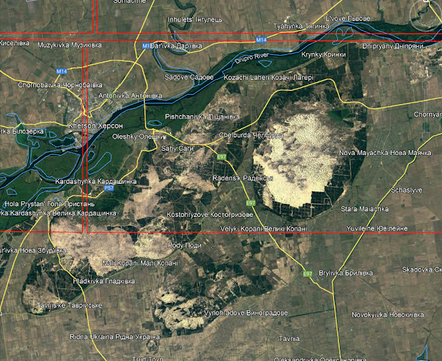
This is an unlikely part of the world, though most maps give no clue to that.  To explain, allow me to include the Google Earth image of the area:


There's plenty of evidence that much of the original land surface has been steadily encroached upon with irrigation, remembering that this is a GE map from 1985.  Here's a close up, from 2300 feet elevation:


This is the Oleshky Sands, an oddly tiny area of sand dunes and cliffs, receiving next to no precipitation despite their adjacent presence to a salt marsh along the lower Dneiper river.  There are actually sandstorms.  Until a few months ago, I had no idea they existed.  It's a super-convenient adventure-scape, parked right next to a fair-sized city in Kherson.

Here's my version of the region:


I'm choosing an alternate graphic to represent the sands, so that I'm able to express both the hex type and the desert's presence at the same time.  Makes a fascinating addition to the area's personality.

Saturday 24 December 2022

Olbia & Lakany, south of Lakanadar

 Yep, Christmas Eve and I'm still here.  Everything's done for the holidays except the festivities this evening and tomorrow.  Christmas dinner's been moved off until tomorrow, and that's easy peasy.  Once you've cooked for a hundred people, six is a piece of cake.

So I've got time for a bit of map.  Taking tomorrow off, though.  First day missed since I started this map blog.  So let's start with this isolated tail on the Azov map.  This eastern stretch reaches the edge of Itossia, which won't get mapped for a long while. 


Itossia is an outlying part of the Sanjak of Cumana, occupied by the half-orc Yetabeshi tribe.  I wrote about all this ages ago.  The land itself is nothing special to speak of ... just more steppeland.


This second section, however, is more interesting.  We've come to the mouth of the Dneiper:


Ozi, more accurately Olbia (fixed), is the remnant of a very ancient Greek colony founded in the 7th century BCE, to trade with the Scythians of that time.  It's still occupied by Greek traders; the small region is an Emirate, jointly controlled by Ottoman overseers and a Greek bureaucracy.  The city of Ozi has a Tartar name; the Greeks call it "Alektor."  It's essentially a wholesale transshipment point, with little trade that isn't already earmarked for some other place.  Much of Constantinople's grain supply comes from this one little place.

The presence of the sea makes a complicated mess of the roads.  The way it changes the usual distribution of places and hexes is a fascinating challenge.  I think the result is evocative of adventure, though I'll grant it looks even better when the unmade adjacent areas are also mapped.


But we'll get there.

Friday 23 December 2022

Kherson Sanjak, around Berishan

2nd of two posts today.  Going to do one and a half sections, or three 20m hexes today.


Squeezing down into the region on the lower Dneiper, still waiting to reach the sea coast.  This is all very flat country, carved into fields when not at war.  Developmentally, it's likely been the same for hundreds of years.


Google maps is pushing the Dneiper further south of my original plotting, while the Inhulets river continues to avoid their meeting.  The curl of the latter river tells how flat the country is.  On GoogleEarth, the Dneiper here is one enormous reservoir, but of course in the 17th century it was just a big river ... from things I've read, navigable but not pleasantly so.  The lower Dneiper was known for rocks, shoals and cataracts where the river fell too fast for boats.

Dneiper Sheet

The first of two posts today.

Here's the Dneiper sheet, that I forgot to post yesterday:


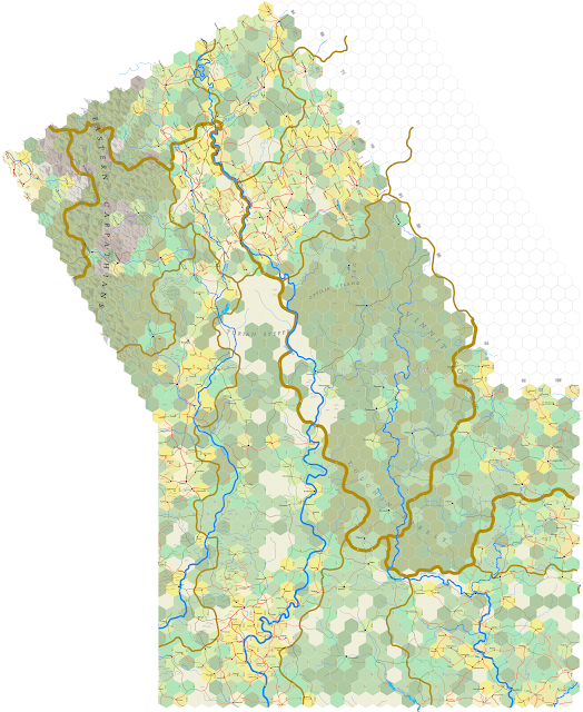
Not that exciting, as most of the page is empty.  I'll add the Kiyev sheet and trim the undone portion off the one above and see if that gives a better sense of space:


There, that supplies scope.  I like the comparison between the splash of orange on the left, which is Moldova around the big city of Chisinau, and that of Vassia on the right.  In between, a few little burgs and villages, with only one decrepit route between them.  Even that has places no better than a cart track.  A bit of a surprise for a party that decides to make the journey with big wagons and not enough replacement axles.  It may only be 140 miles, but it wouldn't be pleasant.  And with strange names and no map, plus villages who couldn't tell them how to get to Voghrad (as they'd have no idea), I wonder how many dead ends they'd reach.

Thursday 22 December 2022

Lakany, around Lakanadar

Plowing along in silence ...


Lakanadar occupies the space that a future Mykolaiv might, only this version of the city is occupied by a mixture of half-orcs, Turks, haruchai and Greek merchants, scattered in multiple villages and one big city around an estuary with minimal tides ... and yet a salt marsh to boot.  That 303 infrastructure promises a dense development and it doesn't disappoint.


I love how an area like this manifests, with the various villages starting out with a scattered complexity that's made sense of by the inclusion of roads.  The navigable rivers add character to the area that isn't found in these big expanses of flat lands I've been mapping.  A section like this restores my interest and pushes me onto the next map.

Wednesday 21 December 2022

Kherson, from the Inhul river to Tikha

Headaches aplenty.  Yesterday's section overlapped three map sheets ... and while one section today overlaps only two sheets, the last also overlapped three.  Plus the fact that one of those had to be created from scratch as well.  Sigh.  Let's get on with it.


The section above consists of the lower Inhulets river, east of the Inhul.  It includes a part of the Dneiper sheet that disappears in the completed version below, which includes only what's on the Crimea sheet.  

I had the Inhulets river pouring into the Dneiper, but no.  Updating and fixing things is good.  Yes it is.  The reader can see from the numbers that infrastructure is falling off as we go east.  That trend continues eastward, but as can be seen, towards the south the development improves.


More steppe and I'm liking the pattern forming, with villages at least 12 miles apart.  Not much to say that I haven't already said ... so let's just move along.


This next section overlaps to the east and north, so I'm doing half the section at a time, since all of the west end is on this map.  I forgot to take the screen shot before starting, so the layout of villages, the Dneiper River and hex types are already there.  Half a hex doesn't take long, but of course this one had to be copied twice.  Here's the hex completed:


This part of Kherson has been hard-fought for in the 2022 war.  For those who might be interested, the village of Kachkar on the map corresponds to Kachkarivka, one of multiple places that Ukraine recaptured on October 4th, after Russian forces were forced to abandon this side of the Dneiper.

My next step was to create a new sheet to the east: L.37e - Sea of Azov:


Look at all those easy-to-map sea hexes.  I've added the little bit from the Crimean sheet in the corner; here's a close-up:


The real world name for Tikha is Velyka Lepetykha, which at present remains under Russian control.  According to this story, the town is one of six that the Russians began to forcibly evacuate on November 6.  Looting is reported.

Sobering.  I'll decline further comment and post the completed map:


Tomorrow I'll post a completed version of the Dneiper sheet, which is also being left behind now as we continue south.  The next line of sections proceeds, with three and a half sections to do to bring the map's edge to the hex immediately west of Vesoi.

K.30e - Kiyev Sheet

First of two posts today.  To begin, here's an image of the Kiyev sheet, to date.  Won't be finishing that upper right hand corner for awhile.


Labelling still needs work, at least from the standpoint of large pictures.  Got to darken up the geographical descriptions and the political labels also.  But, not pressing.  Play around with it going forward.

Here's an image of the Czernowitz and Kiyev sheets together:


Gets harder and harder to see the whole picture without having to give up a level of detail.  Mostly it's just lines and hexes, unless we know just what we're looking at.

On the subject of forward mapmaking ... yesterday I talked about the ragged edge of what's been mapped so far.  Here's an updated image from GoogleEarth for the sections that have been completed:


So, not nearly half of the Ukraine done.  It's a big country.  But the reader can see what I mean by the eastern edge.  My intention is to the continue with a southeast progression until coming even with the yellow rectangle on the map, though that means doing more that three sections in a line before moving south.  Then, with that evened up, I'll come southwest until I hit Bulgaria and Thrace in Turkey.  There's a small chance I'll map some of Bithynia, the bulge showing in Turkey south of the label for the Black Sea.  I'm actually looking forward to mountains.

Tuesday 20 December 2022

Lakany, east of Ipsaklava

Sliding off the Kiyev sheet map onto L.34e, here's a whole view of the sheet we're cutting across:


For those curious about the location of Kherson, there it is, upper centre.  The eastern edge of my mapping hexagon (as it appears on GoogleEarth) is ragged, so I'm going to straighten that up ... which means at some points I'm going to do more than 3 sections on several rows.  That should take us right off the right edge of this new map and onto the next.  At the top of this one is the section I did last night; here's a close up image of it before mapping:


At the top is some overlay from the Kiyev map, so I could hook up roads and rivers as need be.  This particular section spreads over the corners of both the Kiyev and Dneiper sheets, so I wound up copying it twice and cleaning up the edges ... which took me nearly two hours last night.  A bit annoying, really.  But it's done.  Here's a close-up of the done map as it appears on the Crimea sheet:


The snake on the left is the Southern Bug's estuary, somewhat reimagined from Google Maps.  Part of the mapping includes assessing what a lake or a sea coast might have looked like before it was drained, dyked or irrigated out of existence.  It also means checking to see if a lake is real, since numerous existing lakes on these maps are reservoirs created in the 20th century.  As a species, we've been very diligent about damming every river we could for hydro-electric power, which in some cases has created some beautiful waterparks and elsewhere has left unpleasant mud-holes.  Give and take.

On to the east.

Monday 19 December 2022

Lakany, Krivassa & Kherson

I was getting a little tired with how slow I was moving through central Ukraine, so I took some time on a slow Sunday, yesterday, and did six sections.  We have a lot to talk about.

Starting with, first, this part of Lakany, northeast of Vozakan.


This links up the Southern Bug.  Note the elevation numbers in the corners; the "6" near Privolson is that many feet above sea level, so we can see how close we are to the Black Sea.  The "738" ft. figure for Lakany is a mystery to me, since I couldn't find anything on GoogleEarth to suggest that elevation, meaning that my source material was in error.  Doesn't matter, really.  I've already committed myself.


All through this area, the rivers are about 200 ft. below the plateau stretching towards the sea ... not enough for a hill symbol, but worth noting.  The infrastructures are thinning out, letting some steppe-hexes through, but not many.  As we progress east, however, the roads also thin out, with the occasional centre becoming more isolated.  Mykil is 18 miles from Abrono; that's a long journey given the density of places we found in Vassia.

Here's the next two sections to the east:


This stretches east to the big city of Krivoi.  However, when you read "Krivoi" you should be thinking "Pittsburgh."

There are certain places in the world where iron ore and high grade coal lay side-by-side in a way that makes it brilliant for making steel.  The Ruhr is one such place; Silesia is another.  Others include Pittsburgh, Shenyang and two places in Siberian called Kuznetsk and Minusinsk.  Way, way out in Siberia.  Where it gets brutally cold.

Forgive me while I get political a moment.  The Ukraine has two such areas, about two hundred miles apart.  The bigger one is the Donetsk, which the Russians have occupied since 2014.  There's a great amount of fighting going on over this region, as it was the old Soviet Union's most valuable geographical asset ... which it lost when the Ukraine became independent.  The other coal-iron area is called the Kryvbas, though the coal part is lacking while the iron very much is not.  This is what the Russians want in this war; they want to stabilise the Donbas and they want to take and hold Krovoi; this summer they failed spectacularly in doing both.  But here's something to think about: the west, especially the Germans and the French, are chest deep in the Kryvbas' development; the Kryvbas is one reason Europe wants the Ukraine in the E.U., and if you want to understand why American and European weapons are expensively being sent to the Ukraine, it's here.  If the Kryvbas fell into Russian hands, the price of steel would shoot up, it would sustain the Russian's future war machine and it would be a disaster for many companies who can't afford to lose the place as an asset.

But, as I said, Russia choked and didn't get there.  How come the press hasn't mentioned any of this?  Well, I'll point out the press said jack shit about Cominco's interests in Kosovo in the 1990s, too.  There are very definite muzzling aspects about wars carried out for the benefit of huge multinational conglomerates ... mostly because they own the press.  But go look for it.  The information is out there.  It's just not mainstream, and most of it's written in a way that if you don't know how important Krivoi is, you won't understand why the reporter's discussing it.

Oh, nearly forgot.  Krivoi is Ukrainian President's Volodymyr Zelensky's home town.  He knows exactly how valuable it is.

Mapping Krivoi, then.  I had a surprise to discover there was a big inconvenient lake where I'd previously put the road south of Krystofos above, so some changes needed to be made:


I thought I'd give a wide scale image of the area; sorry if this makes it difficult to read the post and look at the map at the same time.

We haven't seen Krivassa yet.  This is again a made-up province for Little Tartary.  It corresponds to a "raion," or political district that's part of the Dnepropetrovsk Oblask; the city of Dnepropetrovsk (not on the map) has been renamed "Dnipro" since 2016.  Which is easier to say.  It's an eastern bulwark against the Zaporozhians, controlling the west bank of the Dneiper while the latter controls the east bank.  Krivoi isn't a market town, just a big manufacturing burgh in my game world; the outlet market is Kopol, shown on the bottom right of the map with the name cut off.

One last thing about Krivoi. A look at GoogleEarth around the city is fascinating; the city is surrounding by open pit mines, many of which have been closed.  The image shown shows three big ex-pits, with the lake appearing on the map for scale.  I've set the mouse so that it gives the elevation on the nearest, biggest pit, shown in the bottom right of the screen, -925 ft.  The level of the land is 190 ft. above sea level, so this makes the pit nearly 1,100 ft. deep.  The other two are slightly less deep, -566 and -475 ft.  The big pit is 2 miles from edge to edge.  Wikipedia shows them filled with water.

Oh, also, these maps are from 1985.  I use the oldest maps of GoogleEarth I can find.  I leave it to the player to look into what this area looks like today.

Obviously, none of these exist in the 17th century, nor the hills surrounding Krivoi made of the material.  And though it's understood that the discovery of iron in the area began in the 19th century, I'm going to let magic detect the iron before that, so that in my game world Krivoi is a pre-industrial digger of iron ore, just the same.

Moving on, then ...


We're back in Lakany, skipping west and one line south again.  Here's another gap in the Southern Bug that needs connecting.  That river that flows west of Privolson turns out not to be there; it does flow through Privolson, but then it turns south.


There, all nice and neat.  All the rivers drift to the south, towards the Sea.  This is the very bottom of the Kiyev sheet, so I'll be moving south onto the next sheet with tomorrow's post (and copying the top two hexes of that map onto the bottom two of this one).  The Kiyev sheet felt like it took forever to cross.

Two sections left.  Here's the rough:


That's the big Dneiper river on the bottom right, which we'll be mapping soon.  The four hexes here went fairly quickly, with their little bits of infrastructure.  The Inhul and Inhulets rivers dominate the landscape.


That's all of it.  Nice to see some lakes for a change.  This is as far east as the map has ever been, and it's going to to out farther.  But I'll talk about that tomorrow.