
Wednesday, 22 February 2023
Monday, 20 February 2023
Hither Rumelia, around Velbazhd
Seems somethings always in the way.

I know, I haven't been working on these maps. The priority is the book, it's that simple. But I'll go on making maps as I'm inclined. The above is working along the western edge of Bulgaria, though the civilisation here is hemmed in by tall mountains to the south, cutting it off from Greece except along the narrow, wild course of the Isker river, shown flowing off the bottom edge of the map.
Thursday, 16 February 2023
Added North and East of Munich
Looks so much better when it's fleshed out:

Wasserburg is a county attached to the Bishopric of Trier, way the other side of Germany ... so, managed by religious entities. This is part of the reason why it's infrastructure is lacking, as reclusiveness is the order. The land further on is a part of Upper Bavaria, controlled by Munich, but is isolated by the geography and distance from the central province. Once again, it produces that effect where a heavy infrastructure evaporates like night and day.
I failed to mention last week that I've been working on these maps for just one year. The first day I started was Feb 9. I'd say it's been successful.
On to other things.
Friday, 10 February 2023
Hither Rumelia, around Pernik
Reached the western border of modern Bulgaria at last:

Remember when we were just trying to go east through Ukraine? That's a long way north of here.
The Sofia cluster extends outwards to the south, but it stops dead at Macedonia (which is why the border is there). The isolation of that group of mountains adjacent to Sofia is more obvious now, with the plain encircling it.
Not much to say ... I've got to get back to the Streetvendor's Guide, while getting ready for running D&D tonight. Sorry if I'm not going too much in depth into these parts. The Balkans are not a fascination for me, just a series of isolated social cultures that were kept at each other's throats by the Ottomans for 600 years. Converts to Islam tended to be mountain people, who had a distaste for the plains-people already ... and those hatreds between highlands and plains continue to this day. Moreover, the Ottomans kept the various Christian churches of Serbia, Bulgaria, Romania and such isolated (and played off against each other), so that even today there's no solidarity between either the various Orthodox or Catholic churches. It makes for hatred, violence, constant squabbling and institutional backwardness. And it's been going on a long time.
Thursday, 9 February 2023
Hither Rumelia, around Razlik
More of the Rhodope Mountains:

It's been 3 months since I started this blog, in central Hungary. Since, I've moved around in a circle through Slovakia, Ruthenia, the Ukraine, the Black Sea and Bulgaria. I'd hoped to complete a circuit by this time, but there have been distractions. I have to post a complete map, though the scale challenges the eye ... but not just at this time.
There's still some Hither Rumelia to do, but it's much smaller than the further province; we'll be in Macedonia on the weekend.
Wednesday, 8 February 2023
Hither Rumelia, southeast of Sofia
Real mountains, now:

The above features the central massif of the Rhodope Mountains, shown with the double-peaked mountain icons on the bottom left. These are 8500 ft. above sea level or more, which is staggering as the plain eastward is just 840 ft. As such, although they may not be as high as the Alps, they look as though they are from the plain. But what's truly amazing, from someone who can see the Rocky Mountain chain from where I am, is that the whole massif is just 33 miles long. That's less than the distance between Cincinnati and Dayton, or Salem Massachusetts and Worcester. The whole range would tuck neatly into the San Francisco Bay Area.
Goofy.
Tuesday, 7 February 2023
Hither Rumelia, around Sofia
Into the heart of Hither Rumelia:


Several people have remarked on the stark break between civilised and uncivilised places ... and there may be some imagination that this is a phenomenon I've incorporated for my 17th century setting. True enough, my populations are a fifth of the modern equivalents, or less. But have a look at the above on Google Earth, with a little wider frame:

It can be seen clearly that even in the modern day that there's a sharp line between "civilised" and "wilderness." Imagine what this must have looked like before the tractor could plow this much field, before the dam that makes the large reservoir bottom centre, before the spreading suburbs of Sofia, when the population density was much higher because there were no roads or even horse carriages for most people. The old saw is that most peasants never went more than 7 miles from home; imagine these places, where 7 miles puts us behind a mountain 7,000 feet high.
In running as a DM, do make the most of that transition. Say directly to the players, "As you watch the last house disappear behind the screen of trees, you realise that there isn't another living soul in the woods ahead of you. From here out, you're on your own." Stress it. Make them really think about the lack of support networks and last minute cavalry arrivers. Make that distinction real ... and with the distinction, that you as DM aren't here to save them, but to run the wilderness AS IS. "Sorry, guys. I'm going to have to run this savage land for what it is. A place no safe person would go."
Monday, 6 February 2023
Mameceqtaw, around Wahkayoh
In response to Discord's request for more Michigan:

Not marked this time around, but the west part of the map between the dark yellow boundaries is an Ojibwe "tribute state" of the Memeceqtaw Country, what's known today as the Menominee native tribe. Reflecting the Upper Peninsula, population continues to be minimal and the infrastructure reflects that. Practical roads are local and specific between hamlets and thorps, rather than part of a widespread trade system. Trade is carried on over water, along the coast, this being more practical than cutting a road through Michigan's rocky, forested wilderness. Valuable products are furs, game meat, unique woods and canoes.
Sunday, 5 February 2023
Hither & Further Rumelia, around Filibe
At last, done with Further Rumelia:

Here we buttress against the Rhodope Mts., significant in ancient history in that it cramped the Greeks against the sea, the same way the Appalachians confined America to the Atlantic seaboard for two centuries. It meant that the thinly scattered tribes north of those mountains received little culture until much later, when the Romans came over the mountain passes and annexed these rich farmlands. The development of Byzantium allowed constant access and transport in and out of these plains, elevating them to a rich province of that empire, and of the Ottomans later. These latter control all of this in the 17th century.
The next stage is to build out Hither Rumelia, which is another densely infrastructured valley, but narrower, surrouding the Isker River that flows south through the Rhodope into Macedonia.
Saturday, 4 February 2023
Hither & Further Rumelia, west of Filibe
More of that semi-wilderness cutting Rumelia in half:

Still, this is the western edge of the Maritsa valley, the river flowing through Filibe. There's still more of it, but it'll soon be a memory until coming 'round this way again, when we map northern Greece.
Not much time today, and not much to say about the map above that I haven't said already. Sometimes, it's all about plodding on.
Friday, 3 February 2023
Hither & Further Rumelia, east of Sofia
Having not heard from anyone, I'll continue with Bulgaria:


Sredna Gora is a small mountain range, just 40 miles wide, with four peaks rising above 4,800 feet, with locations all shown on the map above (they're not just symbols!). The elevation on the left-hand hex assured it's lack of infrastructure ... remembering that it would be even more wild in the 17th century than it appears on GoogleEarth.
There's a gap in the infrastructure that runs south from here, dividing "hither" Rumelia on the west from "further" Rumelia on the east. Then it's dense infrastructure again before getting out of Bulgaria and into Macedonia and Serbia ... which are just more wild mountains surrounding densely populated valleys. It's a crazy place.
Thursday, 2 February 2023
Provence, north & east of Marseille
Context is everything. I added the 2-hex section north of Marseille:


Builds fast. Here's the same map with the background of the 20-mile hex map that it's been created from:


Then the two hexes east of Marseilles:

The environs around Pourcieux feature plenty of disrupted terrain, a high elevation and thus a low infrastructure (only 29), despite the surrounding density. Just south of this section, the easier route between Marseille and Brignoles is found along the coast.
Here's a complete map of all that's been done around Marseille so far:


There, Maxwell. There is a small error; the road south of Brignoles should have a thin black line running through it, as it's a trade route into Toulon. I've fixed it on the map; say the word and I'll fix the post here ... otherwise, I'll leave it until next month.
I still have six other former requestors to hear from, plus anyone else making a $10 donation to Patreon who'd like to see some other part of the world.
Wednesday, 1 February 2023
Further Rumelia, around Stanimaha
Bit late today. More of the Maritsa valley.


The infrastructure density is getting me down a bit, but making progress. The above map in southern Bulgaria completes the sheet map M.27e - Varna for the present. Here's a shot of the whole map:

I'll match this up with the next map to the west, when I complete that one. This covers virtually all of eastern Bulgaria.
Tuesday, 31 January 2023
Further Rumelia, northeast of Filibe
Densely populated Bulgaria ...


Filibe, in the bottom left corner, is modern-day Plovdiv. "Filibe" is the Turkish name; prior to the Ottomans taking the city in 1363-4, it was known by the Byzantine name Philippolis, the name it had going back to its founding by Alexander the Great's father, Philip II. It's an old city, a large city, with a high infrastructure, even though it's virtually unheard of outside Europe.
Monday, 30 January 2023
Further Rumelia, around Kazanluk
Pressed for time, but here's today's map:

The Balkans in general are such a confused collection of mountains, valleys, dense fields and empty hinterlands. Until I post a complete sheet map of the area, it's bound to make little sense to the reader now. But I go on posting, to give the sense of the world unfolding in its own way.
Sunday, 29 January 2023
Further Rumelia, around Marsa
Moving south from the last post:

The denser areas do take more time. I'm tasked to search for the various town names, and then there's additional roads to add as well. On the whole, I think these spaces form a framework around places the characters would actually want to adventure. I've never fully realised a game world with this density of population, which means I've never in-depth run a place with multiple type-1 hexes clustered together and a town every six miles. I've given it some thought, but I think that until I actually try to run such a place, with the player's involvement, I won't have a handle on what that'll be like.

This is the 8th post in the province of Further Rumelia. Some provinces are just bigger, is all.
Saturday, 28 January 2023
Further Rumelia, around Beroia
Heart of Bulgaria:

Beroia is a "big" city, nearly 20 thousand people ... which seems a lot for a D&D world, but we visit little burghs like this all the time our world and think nothing of them. Most of us living in actually big cities (Calgary has more than a million) can hardly imagine living in backward place the size of Beroia.
The Goths won here against the Romans in the 4th century AD. At the end of the 6th century, "Beroe" was destroyed but rebuilt, under the name of Veroia. The Byzantines named it Zagore, and in the 10th century when it came under the control of the Bulgarians, it was renamed Borui. In 1371, it fell under the Ottomans, where it remained until the time of my game world. Thus I had a number of names to go with, but chose "Beroia," the original Thracian name. The present city is Stara Zagora.
Cities like this are naturally cosmopolitan, given that each generation has created a new tradition that's followed in some quarter of the city, as leftover Greeks, Italians, Goths, Byzantines and Bulgarians are impressed upon by the latecomer Ottomans. A DM can make use of this to create a vibrancy in some cities that doesn't exist in other places that haven't changed hands, or culture, in a thousand years. Each part of the city is a faction, trying to hold onto its past while sustaining it's identity in a steady flow of outsiders and alternate beliefs. Tapping into this can help the players insert themselves into the world, as they realise that they, too, are outsiders, with a strange, modern viewpoint on everything.
Friday, 27 January 2023
Further Rumelia, west of Suida
Here's the next map going west.


A portion of the upper Maritsa, the big river not named on the map, flows through the rough country between Suida and Kazanluk. Today the valley is densely populated, but there's also a large reservoir that makes me think much of it's been irrigated by the collected water. Either way, in my game world, it's a dense forest that separates the east population density from the west. The infrastructure numbers at the bottom of the screen (742, 692, 484) shows that it's going to be all dense cities on the south side of this forested reach.
Thursday, 26 January 2023
Further Rumelia, around Kavakli
Slowly, steadily, we march west across Further Rumelia and eastern Bulgaria:

This is a good, long shot, showing the relationship of the area with the coast. I did one-and-a-half sections, including the parts with Golyam, Kavakli and Vaysal. It's a good, healthy adventuring area, with the party needing to make their way to Vaysal on the edge of the hilled forest that surrounds that country town. From there it's plenty of dry, dense hills, in which could be hidden anything. Then it's a long walk to a bigger city, carrying their gold along empty roads through more forested places. Provides a number of interesting possibilities.

This is a good, long shot, showing the relationship of the area with the coast. I did one-and-a-half sections, including the parts with Golyam, Kavakli and Vaysal. It's a good, healthy adventuring area, with the party needing to make their way to Vaysal on the edge of the hilled forest that surrounds that country town. From there it's plenty of dry, dense hills, in which could be hidden anything. Then it's a long walk to a bigger city, carrying their gold along empty roads through more forested places. Provides a number of interesting possibilities.
Of interest to some, "Kavakli" is the Greek name for Topolovgrad, which is noted for the dolmens that occur in the area. This could add another element for the creative DM building an adventure here.
Wednesday, 25 January 2023
Nilnard, around Somolo
A very unself-evident title:

This is a rework of the city of Columbus, Ohio, as it might have been if the Mound Peoples culture had survived and supported by elves, who arrived in America before humans. In other words, a totally fantasy rendering of the area.
A few considerations have to be given thought with the above. While appearing like a European setting, the map above doesn't give details on what a stone road might look like, or how the houses might appear, or what a city layout might be. The various villages and towns might very differently organised, with distinct living conditions and social designs. The map alone is just a step towards building the world here.
I have a vision of houses that are scattered over large areas, between continuous vegetable gardens growing mostly tubers rather than grain crops; the high roads, those in darker red, could be discontinuous black-and-brownstone blocks, each made to perfectly fit with the next, like the example of walls found in Inca cultures. They might have a gutter and a low stone wall that runs on one side, to collect water for crops dug alongside the road. The whole social culture might be organised along communal lines, without the dependence on money for trade. It's really up to us to decide what sort of lives these people lead.
So just because the map looks like it might come from a place in Europe with unfamiliar names, this could be utterly unlike the world we know.
Tuesday, 24 January 2023
Further Rumelia, around Maritsa
Today's contribution:


Here we're encroaching upon the Maritsa River valley, which is intensively cultivated and has a dense population. Infrastructure will be high as we go west, until encountering mountains again.
Tomorrow, I'll be posting the "Mojo of Nilnard" in the Great Oyo Greenwood, the names I finally settled upon for the Ohio request made earlier in the week. I'm ready to tackle that now. We'll return to Bulgaria on Thursday.
Monday, 23 January 2023
Further Rumelia, west of Sizebolu
One section today, still in Further Rumelia:


It must feel a little confusing, as I'm going at this somewhat inconsistently. I need to smooth out the west-side edge of the map as I progress. This section fills in the gap I created in yesterday's map.
Rumelia, like much of the map, is under the control of the Ottomans in the game world. Rumelia in Ottoman Turkish means "Land of the Romans," which was in reference to Constantinople, not Rome. It's the same basic construction that was used for the 13th century Sultanate of Rum, that occupied central Anatolia, was also taken from the Byzantines.
Rumelia is a rolling country with wide, fertile plains; it became the home of the Bulgars after 681, once they'd defeated and driven out the Avars. Being Turkic, the Bulgarians are human, unlike other tribes from central Asia in my world, whom are orcish in race. They adopted Eastern Orthodoxy from the Byzantines and maintained their faith through the Ottoman occupation, unlike other parts of the Balkans that became Islamic. However, the Bulgarian Orthodox church is isolated from the main branch of Orthodoxy, which is located in Moskva.
Sunday, 22 January 2023
Further Rumelia, around Sizebolu
This completes the Bulgarian coast upon the Black Sea.


This completes the coast of Bulgaria upon the Black Sea. The clever observer may notice there's something missing from the map above, and there is. The small town of Burgas was destroyed in the 14th century; a new settlement was built in the 17th, and renamed Burgas, but it doesn't appear here because I've ruled it doesn't exist. Today this part of the world is somewhat densely populated, as Burgas is one of the most important ports on the Black Sea ... but in my game world, this is a backward area, hardly worthy of notice. But the wilds of Rumelia depicted above serves as a defense for Constantinople, with is south and east of here. These are low mountains that have been avoided by armies for thousands of years, dependent upon the small ports that dot the coast. I haven't figured out what their name is yet; I'll need to address that.
From here I'll be going progressively west. It's my intention to fill in the gap shown by the green line, in the image below:

I started doing three sections at a time just southwest of Belgrade, in Serbia. I intend to extend the line out to Sarajevo, then go three more sections westward to even up the line, just as I did in the east. That should take me well into the Adriatic, and cover a fair bit of the Dalmatian coast (lots of islands), before cutting northwest into Bosnia and then Croatia.
This would seem absurd ambition, if I hadn't just done something like it. A few months and we'll brush the edge of Slovenia and Austria. I look forward to it.
Saturday, 21 January 2023
Further Rumelia, around Aetos
Don't have much time to make sense of today's map, upon the Black Sea and part of Bulgaria.

Essentially, it's approximately the middle of Bulgaria's coast on the Black. I'm going to run down the Black Sea coast for 60 miles, which gets just past the Turkish border, whereupon I'll start inland in a westerly direction. I'll put up a general map explaining this tomorrow.
Friday, 20 January 2023
Bithynia, around Cide
Returning to Bithynia, there's only this small corner left, before leaving modern Turkey behind:

Everything else is south and east. When I come back around this way, I'll be doing a great deal of Turkey ... but then Turkey is a very large country, bigger than France, so that I'll be adding to it for years to come.
Before starting on Bulgaria, I thought I'd provide a general map of the coast around the Black Sea, to demonstrate how really huge it is with this scale:
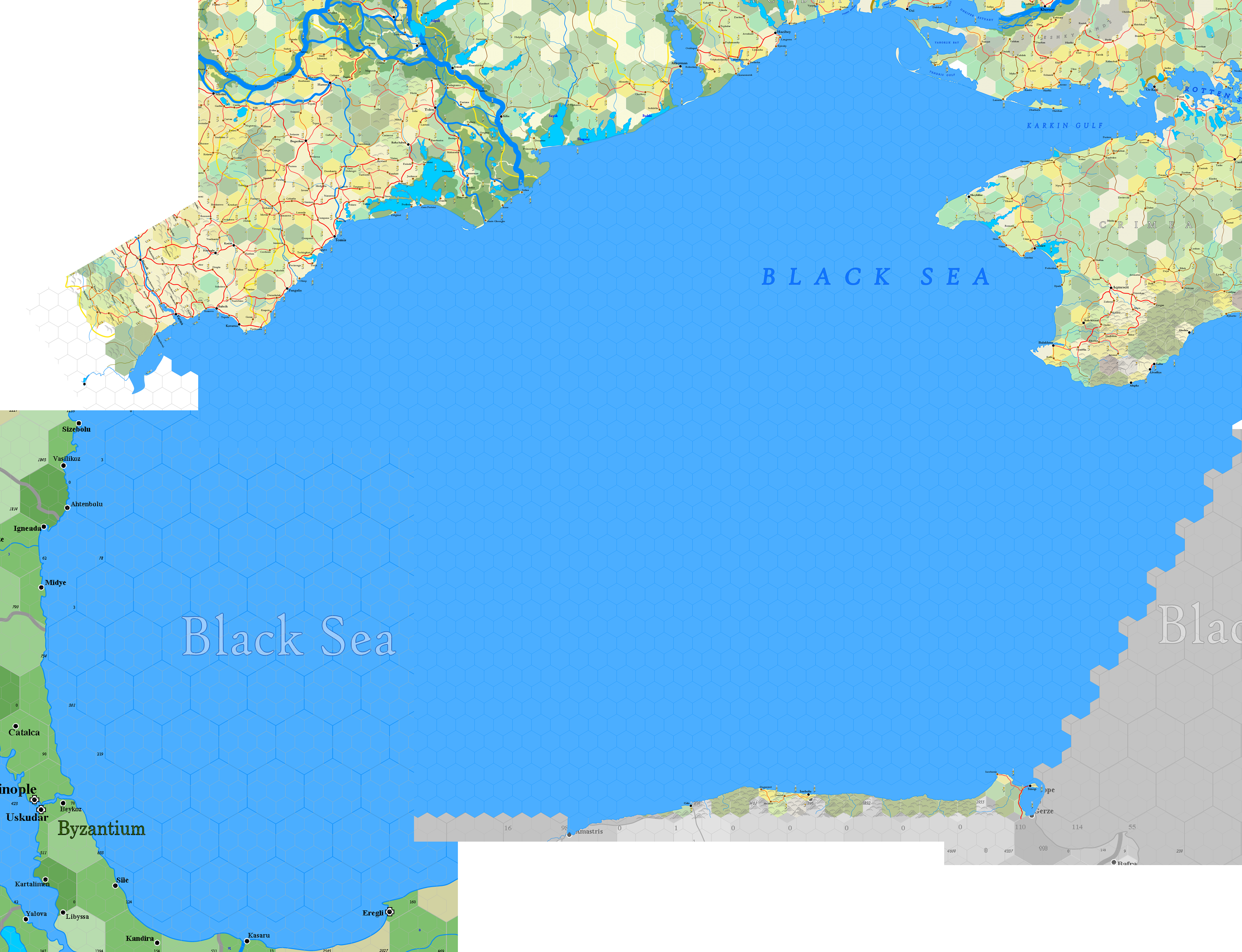
Not all of this coast is mapped, obviously. The big swing around Constantinople on the lower left swings too far south, so it won't be done on this pass. This is also a part of the map where the direction of hexes turns 60 degrees, which is really obvious for anyone familiar with a world map. With tomorrow's post, if someone doesn't intervene with a request, I'll fill in the coast on the middle left, which is Bulgaria, and start moving inland from there.
The reader can see that, although I'm only doing a small part each day, it's just taken two months to map an enormous part of Europe, from Hungary through the southern tip of Poland, across the Ukraine and down into the rim of Turkey. In another two months we'll have reached the Adriatic Sea and, I hope, be on the verge of returning to Hungary.
Thursday, 19 January 2023
Provence, around Marseilles
Also requested by a $10 Patreon supporter:

Marseille is an unusual location upon the Mediterranean Sea in the south of France. In the first regard, it has a spectacular deep-water port, enabling the largest of ocean-going ships to park where they're well-protected from storms. This port was known to the Greeks 2700 years ago, and has been in constant operation since then.
The low plateau surrounding the city is densely populated, but it consists of macchia, a rocky, dry, porous scrubland, impractical for ploughing but excellent for growing olives, dates, grapes and various shrub-based nuts. These are grown and traded south and north for cereals grains from Italy, Spain and the Loire valley of France — especially the latter. Because of its port, Marseille also imports from all over the world, so that the city is a tremendous transshipment point for unloading goods from Asia, Africa and the New World into the European market.
Unusually, however, Marseille doesn't do so from ship to wagon, as there are no easy routes inland from the city. Instead, goods are transferred from huge merchant ships into smaller vessels that take the Rhone deep into the heart of France — making Lyons, Burgundy and Geneva rich. It was this route, the last extension of the Silk Road from China, that created the Fairs that changed the economy of Europe in the Middle Ages. While this route withered for Italy with the discovery of the New World, Marseille was strengthened by the ships that came from the west through the Straits of Gibraltar. It remains today one of the busiest ports in the world.
For players visiting, the key word is bustle. As a DM, I'd stress that there was no safe place to stand, no quiet place to go. Instead, the constant movement of loaded animals and vehicles would force the party to move and move and move out of the way or get run down. As newcomers, they wouldn't understand what was going on, but they'd be able to see there was a LOT going on. Literally the world's produce and handicrafts pouring through its streets, outwards into the world and inwards from it. By D&D standards, Marseille is a gigantic place, with 226,000 people — three times the size of yesterday's Munich.
Back to Bithynia tomorrow.
Wednesday, 18 January 2023
Upper Bavaria, around Munich
As requested by a $10 Patreon supporter:

Requests tend to be for heavily populated areas; Munich sits on a wide, beautiful floodplain with rich black soil, laid down by the Isar River. It also happens to be located in a convenient set of trade routes from east, west, north and south ... particularly the route from Italy through Innsbruck, about 46 miles from the bottom edge of the map. The combination of these things made Munich a phenomenally important place in Europe, sustaining Bavaria as a powerful independent duchy until eventually conquered by Napoleon.
As a stand-alone map, it isn't that impressive ... but the value of these maps is how good they look as piece after piece is added on, giving each part of the map a little more context and flavour.
Tuesday, 17 January 2023
Bithynia, around Inebolu
Continuing westward along the Anatolian coast, skirting the Bithynia shore ...


The mountains are rugged and wild ... even to where they affect the layout of the villages upon them. This GoogleEarth aerial shot of Akcabel, with the vertical at 1:1, shows a scattering of houses along the ridge, 2,000 feet above the sea, just six miles away.

Clearly, an economy reliant upon treenut orchards, olives and grapes, which are traded for more traditional staple foods imported from abroad. And so it has been since the time of the Hittites, most likely.
The isolation is extreme; the mountains behind form an obstacle that can be crossed on foot without excessive trouble, but is certainly past the practicality of a road. Inebolu and surroundings might as well be an island in the Black Sea, as regards communication and trade.
The next post is a location request from a reader, most probably a place in France. Waiting to learn the final choice that's made.
Monday, 16 January 2023
Bithynia, around Sinop
Filling the "hole" that I described as the Black Sea with my last post, I found that yes, I am skirting the northern edge of Bithynia, on the coast of modern day Turkey. The region is massive compared to European standards, with a 500-mile coast that collects together a series of isolated population centres between wild, forested mountains. These cut Bithynia off from the mainland of Turkey except where gaps in the mountains occur ... and in terms of trade, there's only one practical road for use, that south of Amisos. As such, south of the coast, there's a whole lot of sparse, nasty, high-peaked wilderness. Most parts of the province cannot communicate with one another by road, and thus rely upon the sea.


I had to create three map sheets to account for the parts I'll be mapping, though these'll remain largely unworked until I pass this area again. I only touch the very edge of the today's sheet map and then I'm onto the next one. Here's the section that appears:

It's strange that an area with 3,000 years of history still has vast areas of wilderness, but this is Turkey. Looking through GoogleMaps, there's a distinct absence of villages and other occupation all along the hinterland just south of the sea. Sinop is a beautiful looking city that spreads along the peninsula that reaches out from the mainland:

And naturally, it includes the necessary ruins that make it an excellent adventure starting point:

Alas, I won't be working on the hinterland of this place for a while. Instead, I'll be skipping along the north coast of Turkey, following my exacting longitudal line until I reach Bulgaria, where I can once again put the coast behind me and work on pure mainland.
Sunday, 15 January 2023
South Crimea
I've been so sick, and so frustrated at being sick (I just lay in bed and think about how badly I'd like to be working), that getting better, as I have been since yesterday, gave me motivation to push through that frustration. As such, I finished the Crimea ... or as much of it as I intend to do this turn around the map.


So very, very glad to have this done. The mountains are ... weird. I recommend a look at them with GoogleEarth, as you'll find them interesting. I couldn't find an easy source saying so, but I'm guessing the last ice age lopped the top off these mountains ... which is why I created a different mountain symbol specifically for their type and shape.
This also puts two sheet maps in the rear view window: L.34e - Crimea and L.37e - Sea of Azov. Here are those two sheet maps in their entirety:


Much later, I'll come back around to complete the Sea of Azov and the small area of sea in the bottom corner of Crimea. It may seem strange not to just fill in that part of the Black Sea, but I'll need it to line up later on with the map sheet to the south. It's devilishly hard to connect sea edges together without some marker, and knowing what I've done on GoogleEarth works as well as anything else.
The next step is to acquaint ourselves with a map sheet that hasn't appeared on this wiki, M.27e - Varna, and undoubtably to make an additional map sheet to the east of that to flesh out the Black Sea. Here's a GoogleEarth image to show the approximate hole created by the Black that needs to be filled in:

Should be able to move very swiftly through this. Don't know yet if I'll actually cut across the corner of Turkey (Bithynia) ... if I do, it should be a short job of making that toe hold.
Saturday, 14 January 2023
Crimea, northeast of Acmescit
Posting a rather bleak area of the Crimea, just north of the Crimean mountains.


This employs something we haven't seen before ... a river ending in an arrow, rather than debouching in a body of water. These rivers run all year round, nearly. However, with the lack of rainfall, and especially with an unavailable groundwater table to sustain the river's flow, a small amount of irrigation is enough to cause the river to dry up. The arrow head indicates a non-specific location. Some years the river may get further, others not so far.
In places where a river like this is highly intermittent, meaning it only runs when it rains, then the river is represented by a dashed line. I don't expect we'll see a river like this in these maps for a long, long time, but it's worth explaining its presence anyway.
Aqmescit, incidentally, is modern Simferopol. I'll write more about it later.
Friday, 13 January 2023
Crimea, around Gezlev
I'm still feeling plenty down from this cold. This is all I can manage for today:


Thursday, 12 January 2023
Crimea, southeast of Cankoy
One-and-a-half sections today, without fanfare:


Moving steadily southeast. More than half-way through Crimea (what we'll do of it), so we'll be in Bulgaria before the end of January.
Monday, 9 January 2023
London
It happens that I have the plague ... seems like a typical cold. I've had all four shots, so no worry. Don't know how well I'll feel over the next few days, so if there's no post and no work done, this is why.

Here's London, as Maxwell requested:

London has special problems, and not just that it touches six different counties, nor that it's highly overdeveloped. London is so well known to so many people that any tiny error has a high annoyance factor. Every bend in the river, every additional stream, every place name is instantly recognisable. Thus extreme effort is required to get things right ... we can't just use the excuse that it's "fantasy." We have to try.
Still, there are limits. The scale and space won't capture every neighbourhood. That's not practical. As ever, a "sense" is the best we can do. Any actual adventure planned for an area like this requires a very different perspective.
Note, also, with London, Paris, Naples, Moskva, Shanghai or any other medieval city you care to name, the "Big City" isn't just one city, it's dozens. Fantasy RPG products try to pretend that this massive city map with streetnames surrounded by a wall exists in some void, where there isn't another place within hundreds of miles. The thing is, a truly big city is a logistic nightmare; to feed those in the most urban areas, giant transshipment cities develop whose purpose is to collect from the environs surrounding the big city, so as to create an army of wagons that drag flour, fabrics, timber, wrought metal, bricks and much more from the outer edges into the main city. As London grows, it creates cities that grow to feed it, which creates cities further out who gather materials to help the feeder cities, and so the tendrils stretch outwards. You just can't have a big isolated city. It would starve and run out of materials for a few days, no matter how large it's docks were. Without a feeder system to make sure those docks are full of ships, barges and cargo, the dockworkers would find themselves with nothing to unload. The same goes for the gargantuan task of organising goods from the country to get them to the right streets in the big city.
Sunday, 8 January 2023
Ameriscoggin, around Brunswick
Took more hours than I'd care to discuss:


Islands and lakes smaller than 2 miles in diameter are not included; those between 2 mi. and 2.67 mi. are included on an arbitrary basis, depending on whether or not I felt the map needed it. A zoomed-in map could include much more detail.
I wonder how long it takes locals to grasp the complexity of the islands, as obviously there are hundreds not included above that are yet a quarter mile in diameter. In any case, the coast looks less complex above than it did tracing the lines from GoogleEarth.
Pejepscot was an incredibly lucky find. Making the map for Sterling, I'm against a wall in finding native names for places, because for one thing I have zero personal relationship with the area and for another, the internet is notoriously devoid of natives carefully recording their own history for other natives. I'm rather stunned that I can't just locate an extensive wiki for every native tribe everywhere in the world ... but of all the things that people think are important, this doesn't seem high on the roster. A wiki would be incredible for this kind of work. Every native family and place of origin could be carefully tabulated and managed by hundreds of focused, careful Abenaki natives ... but instead what we have are some scrubby generalised texts that list Abenaki bands or random Abenaki words with no context whatsoever. It's staggeringly unhelpful. And yet there's more information about Abenakis than there is about Odawa, that I searched for earlier this week.
Real headshaking stuff. So everytime I have to "come up" with an Abenaki name for a place, it's pick a random word and use it. Yesterday, Sterling corrected my use of "Damiriscotta" for the place just east of Brunswick. Well, I'll admit it. That was a totally random word found in on Abenaki webpage that I used because it was at least Abenaki in origin. Most of the time, this is the best I can do here. So if someone would like to correct some name I'm picking for these parts of the world, please do.
London tomorrow.
Saturday, 7 January 2023
Lower Androscoggin Valley
This proved more intriging than I'd originally expected:

As with the Michigan example, this is a bare-bones 20-mile map of the area requested by Sterling. It's a collection of European incursions established on the edges of Abenaki native lands, so that in calculating the infrastructure it's a mash of both cultures hex-by-hex.

Each "patent" here is a grant made by the monarch of England to an individual or company, in exchange for a service rendered each year. In this case, most likely a set amount of timber to be cut and provided into the hands of the sovereign. The patent grants the specific right to trade with the Abenaki or Penobscot natives. I haven't gone deep enough into the subject to determine exactly what was granted or what specifically the trade desired ... that's going to need my going into old books on the net, because wikipedia is notably scant in its information. The patents all failed as it happened, though not at once. And they did help establish a foothold on the shoreline, which is more important than their intention.
'Course, in Earth's actual history, this was done with the natives as the loser. The Abenaki here, whose settlements can be understood by their unfamiliar non-English names, have been given benefits by elves in America that the real natives did not have. These benefits are based on things that existed in North America, that might have been exploited if the natives had known to do so.
First, the wheel. This gives the natives a better pottery and the potential for taking advantage of moving rivers. And since the elves came to North America first, and brought horses with them, they've been here since long before the Europeans came in the 15th century. Thus there are carts, and with carts, roads.
Second, metal forging. The natives therefore have swords, axes, spears and so on with metal parts. Thus they're able to take a firm stand in war, and the use of metals enables a lot more in the way of tools and farm implements. This allows better planting of crops ... though existing staples are beans and squash rather than cereals, which were never established in the New World prior to the Europeans.
This creates a whole new dynamic, turning history on it's head. The Europeans cannot simply bully their way into America; there are several well-established groups who could fight them to a standstill, and several scattered Elven kingdoms within the large deciduous forests east of the Missouri. For those who may wonder how to predict what the natives have compared to the Europeans, it's best to assume they have everything. After all, what they didn't have prior to 1600 has been since traded by Europeans who began to arrive. There are likely some individual natives planting grain crops, since those too were brought across the Atlantic.
One thing: it paints the Europeans clearly as the invaders, who in this history must give respect to the native tribes or find themselves quickly wiped out. On the map above, the Europeans number about 2,000 persons. There are more than 16,000 Abenaki, as skilled and able, with comparable magic, as the non-gun-toting Europeans here. There are no guns in my game world.
Friday, 6 January 2023
Tahquamenaw, around Munising
Here you go, Discord:


Next month, let me know if you want me to map west, south or east; I'll throw in Grand Island for free, whatever it winds up being named. Onto Maine.
Subscribe to:
Posts (Atom)