Sunday 21 April 2024

Galicia, around Rzeszow


Oops, cut off the 'G.'

This finishes off the Nyatria sheet for awhile, moving onto the Ruthenia sheet.  Those who have achieved the $10 tier can see the combined Nyatria and Ruthenia sheets together in a pdf on my patreon.

This piece above straddles both sheets, so it was a little longer duplicating a two-hex wide band in the middle from one map to the other.  The overlay is what covered up the 'G' in Galicia.  This is still more of that province, which seems to go on and on; the next piece I'm doing includes a small corner of the province of Zerrwen, which surrounds the big city of Lublin — a sort of northern extension of the Galician rural farmland model, though of course slightly more northern.  We're just skirting the southern tip of it here, the least populated part of the province.

The Rzeszow here is randomly presented as one of those cities that was brutalised by recent events brought about by the Thirty Years War, which takes place between 1618 and 1648; for my present-day players, it's 1654.  The map is timed to 1650.  I know the long time readers know this already, but maybe there's one reader for whom this is the first of my maps that they've seen.

Anyway, Rzeszow should bounce back quickly to become an important commercial centre like Debica, but for the present, much of its civil building lay in ruins.  Thus the type-3 hex it sits in.

Wednesday 17 April 2024

Galicia, around Debica

 
Further east now, still heavily populated but beginning to disperse into country towns and villages, rather than commercial and manufacturing centres.  These are still satellite lands of Krakow, as all of Galicia, a large region compared to many of those I've worked on in east-central Europe, this is the powerhouse of the whole Polish state of the era.  Krakow was, for a time, the capital of Poland, in tandem with the other capital in Lithuania, Vilnius, or Wilno.  But the capital was moved to reduce the power of the intellectual class, to isolate the Polish throne from "facts" and "realistic expectations" and so on ... and that went very, very well.

For all of Poland's enemies.

There's much more Galicia to do, until drifting out of this corner of Poland and back into modern Ukraine, around Lwow.  All through the path ahead, I'll be cutting through the region's agricultural heart, right up to where I reach Kiyev.  I imagine that for most readers, a lot of what I'm doing now is a complete mystery to them, a part of Poland they've never looked at in depth.

For example, Nowy Sacz, which was done a few maps ago, is the navigational head of the Dunajec river, just as Krakow is the head of the Vistula.  "Poland" is defined by its rivers, which extend the importance of the Baltic Sea deep, deep into the far reaches of the country, in a great circle from Galicia here to Silesia.  The reason why Poland demanded an open port after WWI is because giving that port to Germany would have been like locking a collar around the entire economic welfare of the whole country.  A German-controlled Danzig would have become spectacularly wealthy on the labour of Poland, and would have funded a war twice the size of the one the Nazis were able to fight.  NO ONE in Europe, in 1919, would have permitted that; they'd have gone to war with Germany again rather than permit that.  So the Germans had to do without it, until they seized it in 1939 ... whereupon it did them no good, because Danzig's trade was throttled anyway by the British Navy keeping the Germans bound to the Baltic and North Atlantic.

It's this trade that made Poland such an appetising prize for the Russians, Austrians and Prussians in the 18th century.  It was the Austrians who gobbled up south and East Galicia in 1772, and then Krakow and Zerrwen in 1795.  True enough, it meant making the Prussians rich, as they controlled Gdansk, but the food production of Galicia and Lwow was prodigious, sufficient to allow Austria to double its population through the 19th century (among other factors). Galicia became known as the "granary of Europe," with its fertile lands producing abundant crops. The region's agricultural prosperity attracted settlers from other parts of the Austrian Empire, particularly from regions facing economic hardships or overpopulation.

Sunday 14 April 2024

Galicia & Wislanie, around Krakow


And so, I build this pile of humanity atop the stack that has been Slovakia, wholly into Poland now.  Feels good to have this density done, as everything after this for a long time is progressively easier to map.  It's all flat, there are less people ... I'll be gaining speed therefore as I go east.

Krakow is a large, important city because it straddles trade in two directions.  To begin with, it's on the headwater of the Vistula river, which flows to the Baltic sea, so that goods throughout south Poland converge here to be transshipped onto barges.  This also makes it a link between the Danube and the Baltic, as it's the shortest distance between the former river and goods coming down from the Baltic, such as furs, timber, fish and, in some degree, Asiatic goods coming all the way from China.  Finally, west to east, it's the fairest way on the north side of the curve created by the Carpathian mountains, linking northern Germany with Kiyev.  In my game, it's a city of 75,000 people, highly educated and at the time, in the midst of a Golden Age.

The region became an area of religious tolerance, replete with scholars and intellectuals like Brozek, Modrzewski and Zacjusz.  It was a time when many Jews settled into the region; Auschwitz-Birkenau is 33 miles east of Krakow, not shown on this map.  The soil was better at the time, though brown and loamy, and because of the decline of the region in the 18th century, had long lacked the fertility it had then.  It is most likely being much restored now.

The next map continues the outward pattern of infrastructure spreading outwards from Krakow.  I'm at the top of the sheet here, but as I have enough room I'm not going to make the adjoining sheet above until I come back this way, many months from now.  Remember when this sheet was empty, not that long ago?


Friday 12 April 2024

Nyatria & Galicia, around Zsolna


The end of Nyatria and I think all of Slovakia now.  For awhile now, I've been progressing east to west with each group of three posts, but now I've climbed up the previously constructed map to where I'm even with it.  Here, I'll demonstrate; here's the upper left corner of the whole map as it's been rendered so far:


The reader can see that it's even now.  I've fixed the error I made with this post and extended the intended line up to include Busko at the top of the map sheet, "Nyatria-18e", which is named after the general area and that the upper right corner is 18 degrees E of Greenwich (an anachronism, but let's be realistic).

As I've explained before, the distance around the world EW is greater than the distance NS, so I've been mapping outwards six 20-mile hexes from the edge; atop the done map, however, I'll just do three 20-mile hexes.  I'll go north from the map finished here, to do the group of six hexes (3 high, 2 wide), then proceed east along the edge of the map shown.  Thus it'll be dense population to Lwow, then it'll drop off towards near Kiyev.  I haven't looked yet to see if I'll be doing Kiyev on this pass.  I kind of like not knowing.

I suppose for most this all seems sort of repetitive.  Certainly the mix of hexes extending along the finger that the Hungarian Kingdom makes east to west, plainly visible on the double-map here seems like a long scattering of similarly patterned hexes.  Let me say that I know that it's just infeasible that this much information could ever really be made use of for a D&D world; it's tremendously out of reason to run every one of these towns in a lifetime of gaming.

Therefore, we can guess that much of my motivation here isn't D&D.  I am pretty nerdy, after all.  I find myself mapping Poland and I think, "wow, not that long ago I was mapping Bulgaria.  This is so kewl to be this far north and actually mapping Krakow!  Goofy, but it's like travelling across Europe at walking speed, which feeds my inner quest for knowledge at any cost.  Some things I do "for D&D" are purely selfish.  I admit it.

I'll skip a description of this area above.  It's much the same as the last two I wrote for Upper Hungary.  The sight of the completed map, overlaid upon the uncompleted areas, I think, is enough.

At some point, I'm going to have to solve the problem of laying two adjacent maps one over the other.  The "Arpathian Mountains," for example, indicates that pretty clearly.  I've figured out how to do it, but damn, it's a lot of work.

Wednesday 10 April 2024

Galicia & Upper Hungary, around the Tatras


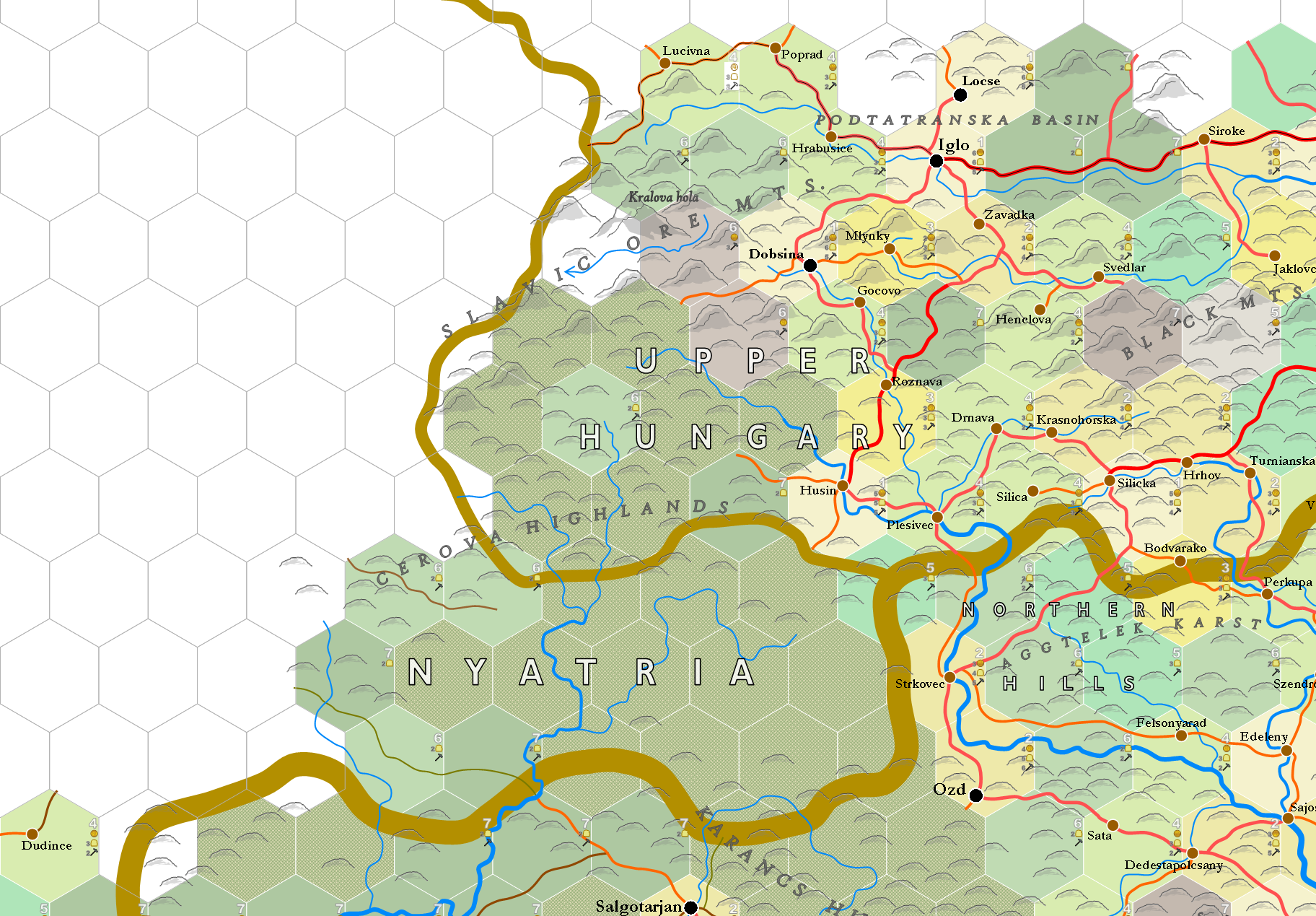
The Tatras are really marvelous; they lift up right out of the plain, surrounded by a flat land.  They were formed millions of years ago as a sharp, staggering wrinkle caused by the collision of the African plate with the European ... with their sharp lifted peaks formed by the glacial period.  Go have a look.  Yet as spectacular as they are, they're just 26 miles long and 7 miles wide.  We could fit six of these ranges into the area of Long Island.

They're an untouched wilderness in the period, primarily inhabited by shepherds and hunters.  The forests today have all been cut out, but they'd still be there in the 17th century, all around the lower slopes.  The upper pastures were tended by a group called the Goral people.

The more populated regions to the north are peaceful and deeply hierarchical, with the peasants being largely serfs, often on the edge of starving.  The Polish nobility of the time ravaged their own land and peoples without restraint, supported by the Catholic Church.  It's a hard place to live, but a player party could likely walk through the region with little trouble, so long as they were generous with bribes, should they be questioned.  Two silver pieces per soldier is a good bribe, all given to the leader of course.

Upper Hungary & Galicia, west of Bartfa


There, I've jumped northeast, so that now we're north of Iglo and Spis Castle.  We've touched on Poland with this recent post and way, way back in November of 2022.  This a relative respite in population density; still have to get around Krakow to the northwest of here, where it's going to get dense again, though not quite like Nyatria.  In fact, there's not a single "settlement" in this region just mapped.

The frontier on this side of Hungary was not much better than the border with the Turks; Upper Hungary was a fortified arm between the Turks and Poland, which was also aggressive. This region was frequently plagued by military conflicts, raids and skirmishes between various factions. These conflicts were more than nationalistic, they also involved local militias, mercenaries, and opportunistic bandits. These clashes often resulted in destruction of villages, displacement of populations, and economic hardship and famine for affected communities. It's a good part of the world for players to help disaffected, struggling peoples against a wide range of enemies.

Major centres depend on the trade route that passes through Eperjes and Iglo, that connects Vienna with Kiyev.  Another interesting point is that, because the peoples here had to huddle together against these troubles (and the 30 Years War besides), the region became one of religious tolerance, with Catholics, Orthodox, Protestants and Jews co-existing in relative peace.  The violent factions are made of other causes.

Monday 8 April 2024

Nyatria, around Nyatria


This is more of the heart of the hard-put Hungarian Kingdom in the 17th century, the source of wealth that sustained the "wall" against the Turks that protected Europe.  For me, thankfully this is the last of intense infrastructure mapping; I adore the way these towns overwhelm the gaze, but it's tons of extra work where mapmaking is concerned.  I yearn for a large, flat, uninhabited landscape ... though when I get there, it'll probably be two hundred lakes that I'll hate.

Nyatria, also Nitra, is an important ecclesiastical centre, but in my game not a trade hub.  Obviously, there's a market there, as the city has more than 10,000 people, but the balance of importance is towards maintenance of the Catholic church and the bureaucracy.  Primarily, all these type-1 hexes are structured towards an intense cottage industry culture, churning out great amounts of foodstuffs, textiles, ceramics and wooden articles of every kind.  And arms and armour, too, for use along the frontier, not for sale.  Military garrisons proliferate throughout the region.

I'm coming up on the corner to turn steadily east, so to make the map round out, I'll be making sections that are just 2/3rds as large as these being lately done.  That will get us up into Poland, whereupon the maps will march out towards Kiyev.

Sunday 7 April 2024

Nyatria, around Zolyom


Depicted is a part of central west Slovakia, south of modern day Banska Bistrica, where about 25 years ago my in-laws went for two years to teach English as a second language.  As we're getting a little further north, the winters here are moderately cold, but the land is beautiful and the highland pastures verdant and rich with livestock.  I still need to identify the line of peaks at the top of the map; part of the Carpathians, but not the Tatras ... those are still further north.

The area is renowned for its rich deposits of gold, silver and copper, so that many hexes here are mining these metals, not just the mine hexes coloured a soft purple at the map's top.  Beszercebanya, or Banska Bistrica, was also known as "Neusohl" at the time, which means "new sand," obviously a mining reference.  "Banska" also relates to mining, while "Bystrica" means clear stream.  Beszercebanya is the Hungarian name for the town, and means "our mine."  No oppression there.

Continuing west from here.

Wednesday 3 April 2024

Spis Castle

Just an update on the previous post.  A poke from Nigel, who more than a year ago corrected me about the right name for Zlin in Moravia, drew my attention to a feature that should have been included on my last map:


SpiÅ¡ Castle has been added to the above, somewhere approximately where it is, atop a low hill not shown on the map.  It is a heritage site, one of the largest castle complexes in Central Europe, believed to have been built in the early 12th century on the site of an earlier fortification. Over the centuries, it underwent numerous expansions, modifications, and renovations. It served as the political, administrative, economic, and cultural center of the region.  There's plenty of information about it.  The castle suffered a devastating fire in the 18th century and thereafter ceased to be occupied.

So why, if the castle existed in the 17th century, at the time of my game world, is it a ruin?  This is going to sound silly, but it's because when I randomly generated the hex, it wound up being a type-7.  The 20-mile hex that it's a part of has an infrastructure (inf.) of 171, which broke down into two type-1s (Iglo and Locse), a type-2 (Zavadka), a type-4 (Svedlar) and three type-7s.  Each type-1 counts for 64 inf., the type-2 for 32 inf., the type-4 for 8 inf. and each type-7 for 1 inf. each.

The two type-1s are automatically assigned to the settlements, about which I've explained, and the other five hexes were assigned randomly.  If the type-2 or the type-4 were assigned to Spis Castle's hex, I'd be changing the town/village name to "Spis" and the castle would be functional and fully staffed.  But the hex generator selected a type-7 for that hex, which would be farmland and a little thorpe of about 15 people.  If Spis had been designated on the encyclopedia map that forms the basis for my game design, it would now be a type-1 or a type-2 for certain.  But it isn't, because the numbers rolled against it ...

I could countermand the random selection and reverse Svedlar's hex ... but once you start doing that with a generative system, it never stops, and the line just creeps all over.  I prefer to say, "This is a D&D world, there's magic, something happened to Spis castle before it had a chance to burn down in the 18th century.  This makes it an interesting ruin for the players to investigate, along with the abandoned village of Spis (which also would have been there before this became a ruin), next to some tiny collection of farmers that live in the shadow of the wrecked castle.

That works great for me, should I ever want to give reason for players to go here, and it works great for the reader, who can build a low level campaign by starting players in the town of Iglo, just 13 miles west of the ruined castle.

Tuesday 2 April 2024

Upper Hungary & Nyatria


Here we have a comparative backwater, though there were overarching conflicts taking place all around the area during the Thirty Years War and the Ottoman encroachment.  I was able to find a reference that much of this area was a big forested area in the time period, surrounding the Cerova Highlands, but that was only one sentence.  There is some trade through the area, and some mining of silver and copper, so obviously a campaign could be built around cleaning out some secret goblin-kobald mine west of Dobsina, discovering they were digging a rich vein of silver and then allowing the party to take steps to continue exploiting it.

Still, life here consists of a mix of rural agriculture, minor commercial activity, a staunch religious tradition (a mix of Catholic and Lutheran), with an outlying threat that wouldn't be likely to materialise.

West, then, into the heart of the modern day Banska Bystrica province.

Friday 29 March 2024

Budapest, Nyatria & the West Border


So many new villages and towns; so many bridges.  So many rivers.  It's easy to tell when the land flattens out, as the rivers begin to braid and small swampy areas appear all round.  The density of the area explains how this region was able to hold back the Ottomans, who were overextended from their political centre.  The map above is our last farewell to the empire for awhile at least, before we meet back with it again in Anatolia.

I'm glad that the population density drops rapidly as I move northeast from here.

The region itself is a mix of numerous ethnicities and cultures, jammed together in the last century as refugees from the widescale European war against the Turk.  Included are Hungarians, Slovaks, Germans, Jews, Moravians, Roma, Croatians, Serbians and many others.  The division between Protestant and Catholic sentiments, combined with the potential for plunder, AND the potential for playing off one people against another, made this region a free-for-all during the 30 Years War ... so "ravaged" would be a very light word to use for the whole area shown.

Onto the western edge of Upper Hungary with the next map.

Thursday 28 March 2024

Bakony, Budapest & Nyatria


Some of these can be brutal to lay out; the roads took just too long with this one, as the path of the Danube through the middle of the densely packed area, coupled with my trying to maintain my road-layout premise, really proved a challenge.  The hex containing Komarom and the next hex to the right had 800+ and 700+ infrastructure.  Since a hex gets a "high road" for every 100 pts., both have more of these roads than the hex has sides ... which means they get an "extra" road on either side of the Danube.  Yet one of these had to be used to connect Guta with two different settlements off-map, so the road between Tata and Tardos ended up being a low road.

I don't suppose anyone knows what I'm talking about.

There's still a part of me that wants to connect Sturovo to Svodin (honest, these places are on the map), but then, the primary form of trade through the middle here is on the Danube itself.  The best way to connect with Svodin, as well as all the shown area of Nyatria including Guta, is to ship it down river to Moca, Iza or Zlatna.  So I left the extra road west from Sturovo out.

As I said with the last post, Budapest (the Ottoman Empire) controls the south bank of the Danube, Nyatria (and the Kingdom of Hungary) the north bank.  The actual price of goods is set by Danube traffic, which is why there's no official "trade route" shown, as would be indicated by a road with a black line down the middle.  You can see the route between Pozsony and Koszyce at the top left, running through Hul, Mana and Kalna to Leva at the top.  Obviously, the road west from Esztergom would be used continuously for trade, but on my trade map of the "known world," none of the roads here are "trade routes" specifically.

The city of Budapest controls the trade on the south side of the Danube.  Just off the map to the west is "Yanik Kale," modern Gyor, which is the last far west fortification of the Ottomans.  That'll be mapped with my next effort.  The next section is even more populated, with even more cities and more roads, so I'm not looking forward to it.

Oh, there's an error I didn't notice.  The high road from Nagysap needs to be connected with the cart path from Csakvar, which I laid out yesterday.  That'll be fixed the next time this area is posted.

Wednesday 27 March 2024

Bakony, Budapest & Northern Hills


At last, Buda & Pest.

Both were wrecked considerably in attacks from the Ottomans, but also during the 30 Years War, taking place just before the time of my world's game play.  Both cities are under the control of the Ottomans and will remain so for many decades yet, before recovered by the Hapsburgs (or perhaps some player party).

The Danube valley here forms an important trading passage, called the "Danube Bend."  In points, the river flows through a narrow gorge flanked by hills, provided a natural passage connecting the Great Hungarian Plain with the Transdanubian region of Vienna.  All along the banks of these type-1 hexes are fortifications and castles, protecting the west from the east while maintaining control over the considerable river traffic.

The Ottoman's control the south bank of the river west of Esztergom, while the Hapsburg-Hungarian kingdom controls the north.  The three provinces of Budapest, Bakony and Northern Hills are all part of the Ottoman Empire, which I'll be leaving behind soon enough.


Nyatria Map Sheet


For fun, here's the next map sheet north of the Croatian sheet, which I've just moved on from.  I've duplicated that material appearing on the Croatian sheet along the bottom, and printed this with the 20-mile map in the background, so the reader can see the infrastructure numbers that have been generated for those hexes.  Some regions on this may haven't been so calculated, and that'll have to come before my moving off this sheet.

The thin orange line that slants up and then to the right is the outward boundary of while I'll be mapping before putting this sheet to bed.  As can be seen, I'll be doing that heavily populated aisle along the Danube valley, then up through the main of western Slovakia and across the Tatra Mts., which are mid-map around Zakopane.  Then it's clearly into southern Poland and Galicia, just grabbing Krakow before I start off in an easterly direction.  Silesia, and Zlin, gets missed this time around.  One of my readers who is interested in Zlin is probably disappointed.

Tuesday 26 March 2024

West Border, around Szombathely


This brings us into a new part of 17th century Hungary, the "West Border" or sometimes the "Western Borderland."  This was the best passage through Hungary to Vienna, and was thus a battleground for about two centuries.  Szombathely is a pretty big city of more than 17,000, and is essentially a big overbuilt fortress.  Austria is just across the border on the left; "Styria" and the town of Jennersdorf are in modern Austria.

Something else to think of was that the region, plagued by raids and burned crops, suffered from an endemic famine, though trade, agriculture and artisanship continued to persist as well as it was able.  Disease, too, was a constant threat.  If there's anything that will make players quickly depart a region or go around, it's telling them that disease in the area is rampant.

The reader may notice the area atop the map labeled "Guns."  In German, this is more properly "Güns," the German name for modern Köszeg.  As far as I can determine the name has nothing whatsoever to do with the modern term "guns" ... it seems to be a linguistic coincidence.  I admit, it sounds odd in a D&D context.  I won't be mapping that region until I swing all around my presently made map and pass here again.

This nearly finishes the map sheet; I have to do the next one over to fill the empty white hexes at the top.  When I plug those in, I'll publish the whole map sheet to my Patreon.

Wednesday 6 March 2024

Bakony, around Veszprem


And this finishes Lake Balaton.  The landscape all around is farmland with commercial centres designed to collect food and alternately process it or take it on to somewhere that does.  I think I failed to say before that the region is under the control of the Ottomans, so the general direction of food transport is south and east, not north towards Budapest or Vienna ... and yes, those cities dearly miss the good old days of the 15th century when this land was theirs.  It hasn't been since 1526, however.

Consider, that means 5 or 6 generations between the lost Battle of Mohacs and the time of my game world.  There isn't a person left alive who remembers when this was Hungarian territory ... though people do tend to maintain a great deal of nostalgia for past times, even when those happened a long, long time ago.  To put it into perspective, imagine that the United States had been under the control of the Mexicans since the year 1900 ... 124 years.  That's the space of time between Mohacs and my game world.  Would the residents of the Atlantic Seaboard, the Midwest and the Pacific Coast today, having been Mexican citizens all these years, still pine for the old America of late 19th century imperialism, second-rate presidents and a disastrous post civil-war reconstruction (which must have failed if the Mexicans invaded successfully) ...?

I think probably yes.  Though they'd have no idea what exactly they were missing.

Monday 4 March 2024

Bakony, around Belgrad


A wider frame for this post, though I've just added the small area in the middle.  This includes adding another quarter of Lake Balaton, so that lake is taking shape.  Another smaller lake east of Belgrad, Lake Velence (in English, "Lake Venice") is listed as the third largest lake in Hungary; I assume they're counting Neusiedler See, which Hungary just barely shares with Austria, and though quite big isn't as large as Balaton.

Budapest is inside that little notch that's blank on the upper right, on the Danube that's shown here.  That river has been getting progressively smaller as I map upstream ... there'll be a little more of that river in the near future.

Belgrad is the modern Szekesfehervar, which I think means "Szekes in Feher county."  Feel free to correct me, what do I know?  A little research revealed that a protected natural area nearby is called in English — if it can be believed — the "Watermelon-infested Nature Reserve," but even the Hungarian wikipedia doesn't explain why.  Just kicking this out there to prove the world's a strange place.

The above is three sheets laid over one another.  The cut-off lines exist because the lower left sheet hasn't been duplicated on the upper sheet yet.  I'm going to leave that until I finish all I'm going to do with the Croatia sheet.

I'll finish Lake Balaton with the next post.

Sunday 3 March 2024

Squeezed against the Edge


I should have just tacked this on to the end of the last post, which I put up about two hours ago, but I didn't think of it.  The image above shows the rest of the map sheet I'm working on.  Note there are just six hexes between the mapped area and the edge; this translates to being two 20-mile hexes wide.

I've been posting sections that are 9 hexes high and 6 sections wide, which translates to three by two 20-mile hexes.  What I'll have to do with the above is make an area 6 by 6 hexes, and then copy the top two hexes of that onto the next map sheet in order to keep going.  This is easier than doing a 9 by 6 area ... so well do the three 6 by 6 sections first, then continue as I have done before.

This can't possibly matter to anyone but me and a few serious map nerds, but heck, it explains why I'm doing what I'm doing with the next three posts.

Finishing a sheet is always an annoyance, what with the duplication of the edges that has to be done so the maps can be lined up.  I've done so much of this, however, that it's not a big deal.  It just slows me a little.  However, towards the end it feels like I'm being squeezed against the edge of the map.  I obviously prefer to have a big empty map to fill up, then getting towards the end of one.

Saturday 2 March 2024

Lower Styria, Croatia & Carniola, around Pettau


There, haven't mapped anything in a few days.

Except for the last corner of Croatia, the rest of this is still part of the Hapsburg (or Habsburg) Kingdom.  Carniola and Lower Styria are both a part of modern Slovenia.  Marburg is just there as a placeholder; the modern name is Maribor.  The other side of the border at the top left is the beginning of Austria.

However, this is as far west as I'll be mapping for a long, long time.  Now it's northeast to Poland and then east.

Tuesday 27 February 2024

Likes

On most social media sites, which includes anything which can be jointly read by a widescale number of people, "likes" serve as a form of validation.  Posts and content with a higher number of likes are given more visibility, because algorithms, for all their evils, prioritise content that receives approbation.  More likes push content to the top of feeds and suggests its importance to other.  The more likes a post receives, the more likely it's going to be seen by a large audience.

Further, likes are evidence that a reader has actually engaged with content.  Liking a post requires minimal effort, yet it shows support, agreement, or simply to acknowledge that the content has been seen.

For content creators, like myself, likes serve as a feedback mechanism.  It acts as an encouragement for more product.   For a creator, the opinions of the reader are of great importance.  So please, in addition to giving your support in so many other ways, please consider taking a moment when you see something I've posted on Patreon and press the like button.  It may seem unimportant, but every metric matters.  Every vote counts.  In the long run, it could make a very big difference in the number of people I'm someday able to reach.

Croatia & Bakony, around Varasd


Provides a little more of Lake Balaton at the top, with a slightly less developed agricultural plain than the last map.  The Croatia shown here is a mere rump of the modern state, controlled by Hungary at this time and having surrendered territory to both the Hapsburgs and the Ottomans.  Nonetheless, it is part of the bulwark "protecting" Europe from Vienna and the heart of Germany.  I put the word in quotes because any serious effort to overrun Croatia isn't going to meet sufficient resistance to keep something as large as the Ottoman Empire from succeeding.

In the period, the region did experience passing military campaigns, raids and occasional occupations of some its towns.  The time period had considerable influence on the future resilience, stubbornness and strong religious ties of Croatians overall.

I've got one more step west to make, an infrastructure-dense area consisting of Lower Styria and an small corner of Carniola.  It finishes off Croatia also, and will be the furthest west that I've mapped using this map formula.

Sunday 25 February 2024

Bakony, Croatia & Slavonia, around Kaposvar


Western Hungary, with a large flat plain and good farmland throughout, a fairly middling population and next to no heavy development.  Even Kaposvar, with a population above 5,000, doesn't rate a type-1 hex.  Mozsgo, in Alfold, was generated last time I was mapping Hungary.

The large body of water at the top is Lake Balaton.  Some may be familiar with in on maps of Europe, but it's going to look quite different here.  Wikipedia discusses how the lake wasn't developed until the 19th century, when the swamps around the lake were filled in.  As such, I'll be using the guideline shown in the attached diagram, reading the old shoreline from GoogleEarth to get details.  The part shown on the map above is the middle bottom on this diagram, slightly to the left of centre.

The expanded lake should look positively massive in this scale, forming quite an obstacle.  My original research on Bakony shows it to be something like the Saskatchewan of Europe, though obviously a lot smaller.  Viewing the next area over, it should look more or less the same as the above, with more of Balaton added.

The lack of topography makes it much easier to get these sections up more quickly.


Saturday 24 February 2024

Banovina, Kordun & Slavonia, around Agram


This represents the heart of later Croatia, and in the game world an important arm of Hapsburg power in Europe.  The sparse region at the bottom left is Lika; I forgot to move the label.  "Karlstadt" (in English, "Charlestown") in Kordun was founded in 1579, quite recent in my game world.  It's a small town, but later in the 18th and 19th century, it would transform into a lynchpin connecting Austrian Croatia with Fiume, the Empire's critical port on the Adriatic.  Later, it'll be known as Karlovac.  Here, it's just a little village of 424 people.

With Banovina done, I'm going to be turning the corner and starting off towards the northeast.  I'm so pleased to be out of the constant creation of mountains and hills.

There's a small layout error at the top with the hex and the border.  I do my best, but these things proliferate.

Friday 23 February 2024

Banovina to Bosnia, east of Agram


While my "Banovina" includes Agram, or modern Zagreb in Croatia, I'm skipping over the distinction in order to simplify the area.  Banovina is a part of the Hapsburg Empire of Austria, which most modern sources fails to acknowledge was once distinct and separate from Hungary, as the two kingdoms were always acting in tandem — especially against the Ottoman Empire.  In any case, this corner of Croatia at the top of the map is isolated from the rest of Hungary by geography and a low population ... and is therefore more connected with, and dependent upon, the Hapsburgs of Sziszek and Agram.

The latter is about 3 miles off the western edge of the above, and is due to appear in the next post.  The appearance of type-1 hexes shows the central core of modern Croatia ... and such is going to continue sporadically towards Graz in Austria, which is off to the northwest.  I won't quite get to Austria; further mapping will reach into parts of Slovenia and western Hungary, before changing direction to the northeast and ultimately towards Slovakia and the Ukraine.

Banovina isn't very large ... about 1800 square miles, larger than Rhode Island but not as large as Delaware.  It's one of a grouping of similarly sized  or smaller fiefdoms: Carniola, Lower Carniola, Kordun, Lika, Lower Styria and Freising, the last about 120 miles in area and surrounding Skofje Loka in Slovenia.

Wednesday 21 February 2024

Bosnia, Slavonia & Croatia, around Daruvar


As I map progressively into the heart of Europe, the size of the regions progressively get smaller ... especially as we near the Holy Roman Empire.  While Slavonia and Bosnia are part of the Ottoman Empire, Croatia is part of the slim kingdom of Hungary, which in the 17th century acts as a bulwark (note the thicker border).  The Ottomans will cross this frontier once more in 1683, but in 1650 their attentions are elsewhere.  Croatia stands because Christian Slavonia is far less controlled than Islamic Bosnia; nonetheless, the area on both sides of the border is fairly peaceful.

The 1683 advance did pass through parts of Slavonia, and Agram to the west, but as the movement was on such a broad front there's no specific marching route we can name.

For the record, the river at the top is the Drava, while the Sava is on the bottom.

Monday 19 February 2024

Bosnia-Kilis, from Bihac to Petrovac


Still wading through these backcountry parts of Bosnia, and still we're not done with the country.  Bihac isn't even connected to the rest of the country by road; there's a little cart path (not even ruts) that leads down to the Kozjak river (a dry wash on GoogleEarth, due to the dam northwest of Bihac).  The river wouldn't be navigable, but there would be a footpath along it, to provide the only communication to this part of the Ottoman-controlled region.  But then, Lika, Kilis and Slavonia are all also under Ottoman suzerainty.

The sanjak of Kilis comprises an ancient region that dates back to the Stone Age, called Burnum under the Romans and Knin after the 10th century, when it formed a defensive refuge for the kings of Croatia for 500 years.  There's a long description of the region under wikipedia.  I was calling it Tinin, the Hungarian name for the region, but a recent look into it tells me that the Ottomans called it Kilis.  It also says that at some point the name was changed to Kirka, even Krka, but I don't have a date for that change and I suspect someone's confused the region with the island of Krk in the Asiatic, about 20 miles off the map to the west.  Anyway, I've accepted Kilis for it.

Lika is also a former province of Croatia, falling to the Ottomans after the 1493 Battle of Krbava Field.  Wikipedia rates it as a part of Kilis, Krka or Bosnia, but I've chosen to retain it's 7th century roots.  Both Kilis and Like are extraordinarily unpopulated, so when I come to map either of those, they'll be as empty as the hexes around Bihac, with a dense coastal Dalmatia next door.  Won't be for a while, though.  I'm going to skirt one corner of Lika as I map in a northwesterly direction, but this is all I'll do of Kilis until coming all the way around my complete map.

Monday 12 February 2024

Bosnia, Zenucha to Banjaluka


Sarajevo isn't the "heart" of Bosnia.  This is.  While not truly dense, as say northern Serbia, this is yet quite populated.

This is still within the Ottoman Empire.  The reach of that empire is only graspable when one comes close to the ground, when every part of Europe that was under its sway is individually seen and examined.

Sunday 11 February 2024

Bosnia, around Sarajevo


Difficult to do these areas that straddle two different map sheets.  The bottom is part of the Adriatic sheet, while the top overlies the Hungary sheet.  Since I create an overlap, it means copying the content from one as exactly as possible onto the other.

Not much else to say.  The mountain fatigue of rolling east-to-west through Bulgaria and Serbia isn't going to stop.  I know it'll continue on up the old Yugoslavian lands through Croatia ... and while theres a brief respite coming as I cross the extreme west of Hungary and then Nyatria, I suspect I'll pick up mountains again as I pass through the bottom edge of Poland.  Somewhere out there is the big flat land of the Ukraine.  Oh, let the day come.

Wednesday 7 February 2024

Bosnia-Serbia, Visegrad, Uzice


Normally, I create the posted map from six 20-mile hexes, but this is from eight — filling a gap created by my going all the way around my mapped area in a great circle, passing through Hungary, Ukraine, the Black Sea, the edge of Anatolia and finally Hungary and Serbia.  The above brings me back full circle and completes Serbia completely.

The above was especially difficult as it spans over three separate map sheets.  I did a better job matching these together, so the reader would have to look hard to find a seam.

The river is the Drina, which flows north into the Sava and eventually the Danube.  It isn't an accurate representation.  Doing the map incrementally, and the rivers themselves being extremely difficult to follow and read with GoogleEarth, as everything is a canyon.  Somewhere I lost the correct line of one of these rivers and to make it work, I had to "invent" a river connection.  Not going to say where.  It looks pretty good, and it is a fantasy map.

Part of the blame lies in that I began creating the underlying maps in 2004, before the invention of a lot of map-friendly content on the internet.  As such, I decided not to focus on exact geographical rendering ... which is, unfortunately for me, now possible.  Sometimes I regret not starting over at some earlier time — but hell, I was mapping India by 2011, which meant that most of the area I have mapped in 20-mile hexes was done in the first seven years of my effort.  It felt too late to adjust even then.  So as someone committed, I have to stress things like it being a "fantasy" and not being an "exact" depiction.

It's funny because unless we're from the actual place being depicted, chances are we just don't care.  Here's a video for reference there.

'Course, I know every error I've made, because I really care about details and the real world.  And the errors haunt me.  I've made my bed and it's too short for my feet.  The only thing I can do is hang them over and get the soundest sleep I can.

Thursday 1 February 2024

Hercegovina-Montenegro, north of Niksic


The karst shown here is a mixture of bare limestone and dolomite rock and scrub growth.  The region is full of sinkholes formed by the collapse of underground caverns.  There are extensive limestone pavements, cracks and deep, narrow fissures called "grikes."  An abundance of springs exist that form streams, many of which disappear through fissures and travel thence through underground channels.  There are many, many caves.

This is the southern reach of the Dinaric Alps, which spawns isolated limestone formations with precipitous cliffs, groups of peaks and plateau-like areas 7000 ft. above sea level.  These contribute to the overall grandeur and scale of the landscape.  The surrounding forests contained scattered hamlets and tiny villages, with only a few significant settlements grouped around.  It's a spectacular arrangement for low-level adventuring, with plenty of space for the occasional chimera or gorgon ... remembering that the southern portion shown was part of Illyria, on the fringe of the ancient Greek world.  So such beasts would be entirely appropriate.

This puts Montenegro behind me, and this is all I'm doing of Hercegovina for now.  Continuing north, there's Serbia to complete and then the eastern part of Bosnia.


Wednesday 31 January 2024

Montenegro-Serbia, around Taslidza


This is west of the previous picture, completing the last corner of Kosovo.  The terrain of northern Montenegro is unusually irregular and can't be easily drawn on a map.  As such, the symbols I'm using aren't really accurate.  I suggest that anyone interested in real geography use their GoogleEarth to investigate the landforms here ... they're very interesting.

For adventure purposes, I love an area like this.  Surrounded by densely populated locales, with the centre a dense wilderland with the bare minimum of cart paths and trails to allow access.  Sections that are 20 miles across without anyone except whatever beasts or goblinish villages I care to include.  And a dungeon or two, obviously.  A party could run for ten years in an area like this, returning again and again to the small country towns of Dabovici, Jubaka and Janca for moderate resupply, except when they have to head out to really civilised places for unusual gear.

Still going one more section west after this, touching the east frontier of Hercegovina.

Sunday 28 January 2024

Serbia-Kosovo, around Novibazar


Some wild country in northwest Kosovo and eastern Serbia, with two tiny settlements and little infrastructure.  These areas are somewhat easier to design, though the proliferation of mountains takes time.  I look forward to the big open plains of the Ukraine, with nary a hill ... though when I return to that, I'll be missing mountains.

All of these territories for the last couple of months, with the exception of "Cattaro" on the last post, which is under control of the Venetians, are part of the Ottoman Empire.  Despite the geographical obstacles before them, the Ottomans did very well in capturing and maintaining these regions for five centuries.  This left an indelible mark on the land, both in culture and in the manner of financial expenditures and religion.  In the game world, these lands are fraught with repression, religious persecution, blood feuds and political corruption.

The hillpeople, who hated the lowlanders, adopted Islam and become Moslems; the lowlanders remained steadfastly Christian ... though because they were isolated from both Catholicism and the Russian Orthodox entities, they formed local orthodox or catholic chapters that remain independent to this day.

As a pattern for designing game adventures, I find this difficult for my players.  Most aren't invested in either religion or nationalism; it can be hard even for adults to engage in struggles based upon this region's abject hatred for that, on a degree that often seems absurd.  Western soldiers in Kosovo in the 1990s had trouble relating to people's motivations that were based on wild, unrestrained hatred and a desire for genocide — both of which are legacies from such a long time under Turkish rule, where the locals had little control over their futures or social change.  The absence of political control fosters petty discontents.  The 17th century Balkans are rife with it.  Player parties are not, and it's therefore with blank eyes that they respond should I introduce some narrative based on this village attacking that without apparent cause.  So I largely don't.  Too much of it and all the parties want to do is leave and so somewhere more sensible, like France or Scandinavia.

Wednesday 24 January 2024

Albania-Montenegro, around Skadar


There, the Adriatic Sea at last.  I've followed this east to west path since Amisos in Bithynia, in Turkey.  At this point I'm finally ready to swing north.

I know they're just dots on the map above, but these are real places and I find them somewhat interesting.  Take Virpazar, for example, on the left-center, just off Lake Skadar.  A quainter little village couldn't be asked for, just 1.56 km from the lake's algae-ridden shore ... so, in fact, a little port village, though that's not plain on the map above.  The layout is plainly made for a D&D adventure, with it's circular group of houses and the all-important bridge.

There's next to no information on wikipedia, but a tourist link (written in Bosnian) translates as follows by chatGPT:

"Virpazar is a small town on Lake Skadar, with many attractions and tourist activities, and an excellent starting point for numerous hiking tours.  One of the main offerings for tourists is boat trips on Lake Skadar.  In recent years, more and more tourists have been enjoying bird watching. If you didn't know, Lake Skadar is the largest bird habitat in this part of Europe. Lake Skadar is a "bird paradise" with 280 species, including rare ones such as pelicans and cormorants. It's interesting that the seagull, as a marine bird, nests on a freshwater island in Lake Skadar. The rare pelican has become the emblem of the lake.  Don't miss the opportunity to savour dishes and excellent Montenegrin wines that will surely be offered in local restaurants."

There are numerous images of Virpazar attached to GoogleEarth as well.  I like this one:


I want to stress that I've deliberately chosen real places to put on these maps, any one of which can be searched for through Google, Wikipedia or other sites.  If you do choose to run characters somewhere on the maps provided here, be sure and look them up to see what facts there are that might interest your imagination.

Friday 19 January 2024

Kosovo-Albania, south of the Albanian Alps


These feel like they're coming fast; I'm not pressing that hard, but I am enjoying the process.  I could stand a few less mountains.  The Adriatic Sea is now just 10 west of the bottom corner of this add, so the next post will feature a sea coast.

I'm experimenting with a new colour scheme for these snow covered mountains; the colour isn't clear on Blogger, but when I post a pdf of the region on my patreon, it should show the change.  The Sharr and the Albanian Alps are the first I've mapped in 6-mile hexes that are both high enough, and have enough snowfall, to produce an ice-cap.  There's going to be a lot of it if I get to the Austrian-Swiss Alps; pretty sure I'm going to skip past that as I round the corner towards northern Hungary, Bohemia and southern Poland.  Looking forward to mapping the big Lake Balaton in Hungary.

For the time being, it's a march up the length of old Yugoslavia, mapping Bosnia, part of Croatia and Slavonia. 

Though at first glance, each of these maps might seem much the same as the one before, but there are differences I can feel as I choose the placement of mountains, rivers and so on.  The whole reach from central Bulgaria out to Albania has been one hard task of wild, inconsistent country split by multiple, non-homogeous mountain ranges.  It's no wonder that ancient Greece felt trapped against the sea, as these sheer wildness lands took civilisation many centuries to unravel and overcome.

Thursday 18 January 2024

Kosovo-Albania, around Prizren


Made a mistake with my last post, misunderstanding the location of the Sharr Mts.  Where I put the Sharr are the "Black Mts."  The Sharr on are this corner of Albania, the first bit of that land that I've mapped.  That should give a hint of how close I'm getting to the Adriatic.

Added labels, so Serbia, Albania and Kosovo are clear now; Macedonia is cut off to the east.  I won't get back around to southern Macedonia for a long time.  Kosovo is about two thirds done now, with the above showing the heart of that country.  I'm enjoying the process of mapmaking again; it's been too long.

Tuesday 16 January 2024

Macedonia-Serbia-Kosovo, Uskub to Pristina


Mountains and wilderness borderland lacking a label for Kosovo (on the left) and Serbia (top right).  The Uskub region at the bottom is part of those settled lands that gave rise to Philip II of Macedon and his son Alexander the Great some 2300 years ago.

I have to weigh in on the region labels and mountain names, to make them clearer than they've been up to now.  It's a troublesome detail, as there's never room enough to comfortably squeeze in a big title overtop the considerable background.  I tend to kick it down the road because I know where I am, but obviously I need to attend to the matter going forward, so I will.

From here I'm going to continue going west until I reach the Adriatic Sea, which is about 110-120 miles onward.  It's felt good coming back to making maps, and going forward I'll continue posting them in 40 by 60 mile sections, as each is done.  On to the Adriatic, and then swing northwest towards Vienna.

Monday 15 January 2024

Macedonia-Serbia, Vranya to Kocane


Shows the southern border of Serbia where it meets Macedonia ... in a region replete with mountains and forest.  The route shown throught Kocane to Velbazhd (and Sofia further north, off map), is an ancient trade route between Salonika and central Bulgaria.  Historically, the beige region at the upper right is the ancenstral home of the Bulgarian kingdoms that arose in the 6th century AD, as it was a transportation hub between the Aegean Sea, the Danube valley and roads to the Adriatic ... called Illyria at the time.

The forests look like they'd be easier to render, but the hills and mountains, getting them more or less in the right place, drains away time.  Plus, the area above spans over two map sheets, so that after creating some of the map on the right, I then had to copy and duplicate it on the left so the two sheets would match seamlessly.  The above is made of two files; a little examination reveals labels that start and don't finish, or places where the roads and rivers don't perfectly match up.

We do what we can.